IMAGES TAKEN NEAR TO
Wilton Crescent, ALDERLEY EDGE, SK9 7RF
Introduction
This page details the photographs taken nearby to Wilton Crescent, SK9 7RF by members of the Geograph project.
The Geograph project started in 2005 with the aim of publishing, organising and preserving representative images for every square kilometre of Great Britain, Ireland and the Isle of Man.

There are currently over 7.5m images from over14,400 individuals and you can help contribute to the project by visiting https://www.geograph.org.uk
Image Map
Images are licensed for reuse under creativecommons.org/licenses/by-sa/2.0
Notes
- Clicking on the map will re-center to the selected point.
- The higher the marker number, the further away the image location is from the centre of the postcode.
Image Listing (46 Images Found)
Images are licensed for reuse under creativecommons.org/licenses/by-sa/2.0
Image
Details
Distance
1
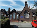
Alderley Edge Community Primary School
At the western end of Church Lane. A white arrow at the bottom of the name sign directs visitors leftwards. Another arrow points right for children and adults (which seems to cover everyone).
Image: © Jaggery
Taken: 8 Sep 2014
0.12 miles
2
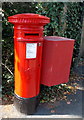
Victorian postbox in Brook Lane, Alderley Edge
Located at an entrance http://www.geograph.org.uk/photo/4172005 to Alderley Edge School for Girls
Image: © Jaggery
Taken: 8 Sep 2014
0.15 miles
4
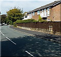
Brook Lane, Alderley Edge
Part of the B5085 to Knutsford.
Image: © Jaggery
Taken: 8 Sep 2014
0.15 miles
5
Brook Lane entrance to Alderley Edge School for Girls
The school is a GSA independent school for girls aged 2-18. GSA is The Girls' Schools Association,
the professional association of the heads of independent girls' schools in the UK and overseas.
GSA is a constituent member of the Independent Schools Council (ISC).
Image: © Jaggery
Taken: 8 Sep 2014
0.15 miles
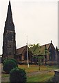
8
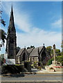
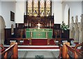
Parish Church of St Philip & St James, Alderley Edge
In the Church of England Diocese of Chester, viewed from Ryleys Lane near the corner of Church Lane.
Image: © Jaggery
Taken: 8 Sep 2014
0.15 miles
10
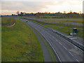
Alderley Edge Bypass (A34)
Looking southwards along the new (2010) section of the A34 by-passing Alderley Edge. View from the bridge at Brook Lane.
Image: © David Dixon
Taken: 4 Nov 2012
0.16 miles