IMAGES TAKEN NEAR TO
Moss Road, ALDERLEY EDGE, SK9 7JB
Introduction
This page details the photographs taken nearby to Moss Road, SK9 7JB by members of the Geograph project.
The Geograph project started in 2005 with the aim of publishing, organising and preserving representative images for every square kilometre of Great Britain, Ireland and the Isle of Man.

There are currently over 7.5m images from over14,400 individuals and you can help contribute to the project by visiting https://www.geograph.org.uk
Image Map
Images are licensed for reuse under creativecommons.org/licenses/by-sa/2.0
Notes
- Clicking on the map will re-center to the selected point.
- The higher the marker number, the further away the image location is from the centre of the postcode.
Image Listing (4 Images Found)
Images are licensed for reuse under creativecommons.org/licenses/by-sa/2.0
Image
Details
Distance
1
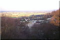
View from the Edge
Alderley Edge: the Pennines are obscured by snow clouds as a north wind makes the viewpoint of Alderley Edge not a place to linger.
Image: © S Parish
Taken: 27 Dec 2005
0.12 miles
2
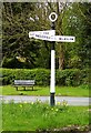
Old Direction Sign - Signpost by Hough Lane, Alderley Edge
Annulus finial - 3 arms; Cheshire CC halo in parish of Hough (Crewe and Nantwich District), Moss Road junction with Hough Lane.
To be surveyed
Milestone Society National ID: CH_SJ8578B
Image: © Milestone Society
Taken: Unknown
0.13 miles
4

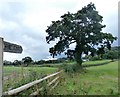
To the Edge, Hough, Alderley Edge
The start of the footpath via Saddlebole Farm with the Edge looming on the skyline.
Image: © Peter Turner
Taken: 13 Jan 2012
0.20 miles