IMAGES TAKEN NEAR TO
Talbot Road, ALDERLEY EDGE, SK9 7HR
Introduction
This page details the photographs taken nearby to Talbot Road, SK9 7HR by members of the Geograph project.
The Geograph project started in 2005 with the aim of publishing, organising and preserving representative images for every square kilometre of Great Britain, Ireland and the Isle of Man.

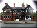
There are currently over 7.5m images from over14,400 individuals and you can help contribute to the project by visiting https://www.geograph.org.uk
Image Map
Images are licensed for reuse under creativecommons.org/licenses/by-sa/2.0
Notes
- Clicking on the map will re-center to the selected point.
- The higher the marker number, the further away the image location is from the centre of the postcode.
Image Listing (111 Images Found)
Images are licensed for reuse under creativecommons.org/licenses/by-sa/2.0
Image
Details
Distance
1
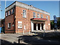
Festival Hall, Talbot Road, Alderley Edge
Image: © John Brightley
Taken: 2 Jun 2011
0.01 miles
2
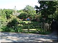
Entrance to allotments, Heyes Lane, Alderley Edge
The footpath which leads to Talbot Road can be seen on the right.
Image: © John Brightley
Taken: 2 Jun 2011
0.05 miles
3
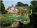
Allotments, Heyes Lane, Alderley Edge
Viewed from the footpath that leads from Heyes Lane to Talbot Road.
The side of the Royal Oak pub can be seen in the background.
Image: © John Brightley
Taken: 2 Jun 2011
0.05 miles
4
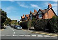
Moss Lane, Alderley Edge
Viewed across Trafford Road from the corner of Stevens Street.
Image: © Jaggery
Taken: 8 Sep 2014
0.06 miles
5
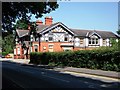
Royal Oak, Heyes Lane, Alderley Edge
Planning permission was granted to replace this pub with housing and the building was demolished in summer 2011.
Image: © John Brightley
Taken: 2 Jun 2011
0.08 miles
6
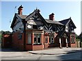
Royal Oak, Heyes Lane, Alderley Edge
Planning permission was granted to replace this pub with housing and the building was demolished in summer 2011.
Image: © John Brightley
Taken: 2 Jun 2011
0.08 miles
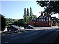
8
The Royal Oak, Heyes Lane, June 2011
Before demolition (obviously) viewed towards London Road, Alderley Edge
Image: © Russell Hall
Taken: 20 Jun 2011
0.08 miles
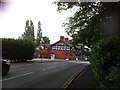
9
The Royal Oak, Heyes Lane, June 2011
Viewed from Davey Lane opposite
Image: © Russell Hall
Taken: 20 Jun 2011
0.08 miles
10
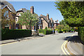
Trafford Road, Alderley Edge
Smart Victorian semi-detached villas line this quiet road close to the centre of Alderley Edge. The name is derived from Sir Humphrey de Trafford, owner of Chorley Hall, who sold land off here for housing development in the late 19th century.
Image: © Stephen McKay
Taken: 7 Jun 2018
0.08 miles