IMAGES TAKEN NEAR TO
Gravel Lane, WILMSLOW, SK9 6LA
Introduction
This page details the photographs taken nearby to Gravel Lane, SK9 6LA by members of the Geograph project.
The Geograph project started in 2005 with the aim of publishing, organising and preserving representative images for every square kilometre of Great Britain, Ireland and the Isle of Man.

There are currently over 7.5m images from over14,400 individuals and you can help contribute to the project by visiting https://www.geograph.org.uk
Image Map
Images are licensed for reuse under creativecommons.org/licenses/by-sa/2.0
Notes
- Clicking on the map will re-center to the selected point.
- The higher the marker number, the further away the image location is from the centre of the postcode.
Image Listing (15 Images Found)
Images are licensed for reuse under creativecommons.org/licenses/by-sa/2.0
Image
Details
Distance
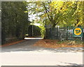
5
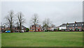
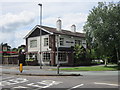
The Pleasure Park, South Oak Lane, Wilmslow
Image: © habiloid
Taken: 27 Dec 2023
0.12 miles
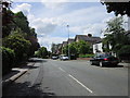
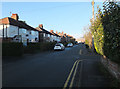
6

Development, Knutsford Road, Wilmslow
Image: © Alex McGregor
Taken: 16 Jun 2011
0.15 miles
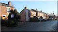
8
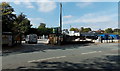
Travis Perkins in Wilmslow
Timber & building supplies premises viewed across Alderley Road.
Image: © Jaggery
Taken: 8 Sep 2014
0.20 miles
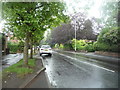
9
Donkey Lane, Wilmslow
Donkey Lane connects Alderley Road on this side with Knutsford Road 150 metres ahead.
Image: © Jaggery
Taken: 8 Sep 2014
0.22 miles