IMAGES TAKEN NEAR TO
Woodlands Road, Pownall Park, WILMSLOW, SK9 5QB
Introduction
This page details the photographs taken nearby to Woodlands Road, Pownall Park, SK9 5QB by members of the Geograph project.
The Geograph project started in 2005 with the aim of publishing, organising and preserving representative images for every square kilometre of Great Britain, Ireland and the Isle of Man.

There are currently over 7.5m images from over14,400 individuals and you can help contribute to the project by visiting https://www.geograph.org.uk
Image Map
Images are licensed for reuse under creativecommons.org/licenses/by-sa/2.0
Notes
- Clicking on the map will re-center to the selected point.
- The higher the marker number, the further away the image location is from the centre of the postcode.
Image Listing (17 Images Found)
Images are licensed for reuse under creativecommons.org/licenses/by-sa/2.0
Image
Details
Distance
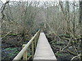
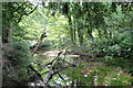
3
Bridle path to River Bollin from Pownall Park, Wilmslow
Image: © Anthony O'Neil
Taken: 29 Mar 2011
0.10 miles
6
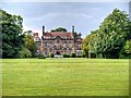
Pownall Hall (School)
Formerly a large house, built approx 1833 for James Pownall. It is now an independent school http://www.pownallhall.cheshire.sch.uk/ . It is a Grade II* Listed Building (Building ID:414633 http://www.britishlistedbuildings.co.uk/en-414633-pownall-hall-school- British Listed Buildings)
Image: © David Dixon
Taken: 8 Aug 2013
0.19 miles
7
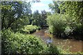
The meandering River Bollin
A view upstream at what could be somehere in the rain forests of the tropics
Image: © K A
Taken: 5 Aug 2011
0.20 miles
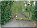
8
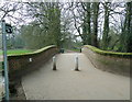
Bridge over River Bollin near Quarry Bank, Styal
Bridle path towards Pownall Park, Wilmslow.
Image: © Anthony O'Neil
Taken: 29 Mar 2011
0.22 miles
9

Quarry Bank Mill Weir
The main weir at Quarry Bank Mill. I have seen a drawing, part of a geology paper, which show a tunnel from the upper water level to the lower level. The fenced off access and closed door in the rock face possibly lead to that tunnel. Perhaps it was used as a spillway in days gone by and is hidden behind the shrubbery to the left.
Image: © Roger Gittins
Taken: 20 Jul 2010
0.22 miles