IMAGES TAKEN NEAR TO
Altrincham Road, WILMSLOW, SK9 4LH
Introduction
This page details the photographs taken nearby to Altrincham Road, SK9 4LH by members of the Geograph project.
The Geograph project started in 2005 with the aim of publishing, organising and preserving representative images for every square kilometre of Great Britain, Ireland and the Isle of Man.

There are currently over 7.5m images from over14,400 individuals and you can help contribute to the project by visiting https://www.geograph.org.uk
Image Map
Images are licensed for reuse under creativecommons.org/licenses/by-sa/2.0
Notes
- Clicking on the map will re-center to the selected point.
- The higher the marker number, the further away the image location is from the centre of the postcode.
Image Listing (22 Images Found)
Images are licensed for reuse under creativecommons.org/licenses/by-sa/2.0
Image
Details
Distance
1

River Bollin at Giant's Castle Rocks
Looking upstream from Image
Image: © David Dixon
Taken: 20 Mar 2012
0.15 miles
2
Giants Castle Bridge over the River Bollin
Image: © Raymond Knapman
Taken: 2 Aug 2013
0.15 miles
3
Approaching Giant's Castle Bridge
The bridge crosses the River Bollin.
Image: © Trevor Harris
Taken: 7 Jun 2012
0.15 miles
4

Giant's Castle Bridge
Giant's Castle Bridge, crossing the River Bollin
Image: © David Dixon
Taken: 20 Mar 2012
0.16 miles
5
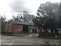
Norcliffe Farm
On Moss Lane close to Manchester Airport
Image: © Graham Hogg
Taken: 14 Mar 2019
0.18 miles
6
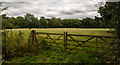
Styal Cross
Fields near Styal Cross.
Image: © Peter McDermott
Taken: 16 Aug 2014
0.18 miles
7
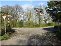
Junction of the Airport Orbital Cycleway with Moss Lane Styal
Image: © Rod Allday
Taken: 13 Apr 2014
0.19 miles
8
Signpost on the Airport Orbital Cycleway at Styal
The cycle route runs around the outer perimeter of Manchester Airport, through the tunnels under the two runways, close to Styal Country Park, along a path running extremely close to the runway, down some country lanes and back past Heald Green before returning to the starting point at Wythenshaw Civic Centre.
Image: © Rod Allday
Taken: 13 Apr 2014
0.19 miles
9
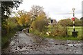
Pre-Worboys road sign on the old Altrincham Road
Now a dead end closed to motor vehicles because the airport is in the way.
Image: © Mark Anderson
Taken: 12 Nov 2019
0.19 miles
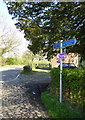
10

Which Way?
This old signpost is at the junction of Moss Lane and Altrincham Road.
Image: © David Dixon
Taken: 20 Mar 2012
0.19 miles