IMAGES TAKEN NEAR TO
Bollin Hill, WILMSLOW, SK9 4AN
Introduction
This page details the photographs taken nearby to Bollin Hill, SK9 4AN by members of the Geograph project.
The Geograph project started in 2005 with the aim of publishing, organising and preserving representative images for every square kilometre of Great Britain, Ireland and the Isle of Man.

There are currently over 7.5m images from over14,400 individuals and you can help contribute to the project by visiting https://www.geograph.org.uk
Image Map
Images are licensed for reuse under creativecommons.org/licenses/by-sa/2.0
Notes
- Clicking on the map will re-center to the selected point.
- The higher the marker number, the further away the image location is from the centre of the postcode.
Image Listing (16 Images Found)
Images are licensed for reuse under creativecommons.org/licenses/by-sa/2.0
Image
Details
Distance
1
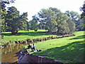
Wilmslow - River Bollin near the east end of The Carrs
Wilmslow: River Bollin from the footbridge on the North Cheshire Way near the east end of The Carrs.
Image: © Mike Harris
Taken: 21 Sep 2006
0.11 miles
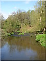
4
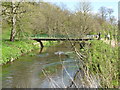
Footbridge over the River Bollin in The Carrs park
Image: © Rod Allday
Taken: 13 Apr 2014
0.11 miles
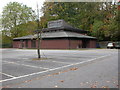
5
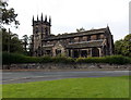
Wilmslow Parish Hall
Formerly in Water Lane on the site of the Information Commissioner's Office the present Parish Hall was built (in the 1980s?) on the site of the old Chancel Lane school.
Image: © John H Darch
Taken: 13 Dec 2013
0.11 miles
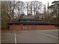
6
Wilmslow Parish Hall
Off Cliff Road, http://www.parish-hall.wilmslowparish.org/
Image: © Mike Faherty
Taken: 20 Oct 2009
0.12 miles
7
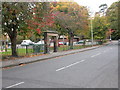
Wilmslow, gate
Gate with stone arch at the entrance to playing fields in Cliff Road; the inscription states that it was gifted by Henry Boddington "for the recreation, health and pleasure of Wilmslow and her children for ever. 1925"
Image: © Mike Faherty
Taken: 20 Oct 2009
0.15 miles
10
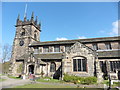
Church of St Bartholomew, Wilmslow
Viewed across Chancel Lane, at the edge of the town centre. The Wilmslow Parish website states that there has been a church on this site since the 13th century, when it was probably built by Sir Richard Fitton, who held the Manor of Bollin. The first evidence of its existence is in 1264.
The church seen here is substantially the product of the rebuilding undertaken by Henry Trafford, Rector between 1517 and 1537. The church was Grade I listed (the highest category) in 1951.
Image: © Jaggery
Taken: 8 Sep 2014
0.24 miles