IMAGES TAKEN NEAR TO
Beeston Road, WILMSLOW, SK9 3SA
Introduction
This page details the photographs taken nearby to Beeston Road, SK9 3SA by members of the Geograph project.
The Geograph project started in 2005 with the aim of publishing, organising and preserving representative images for every square kilometre of Great Britain, Ireland and the Isle of Man.

There are currently over 7.5m images from over14,400 individuals and you can help contribute to the project by visiting https://www.geograph.org.uk
Image Map
Images are licensed for reuse under creativecommons.org/licenses/by-sa/2.0
Notes
- Clicking on the map will re-center to the selected point.
- The higher the marker number, the further away the image location is from the centre of the postcode.
Image Listing (10 Images Found)
Images are licensed for reuse under creativecommons.org/licenses/by-sa/2.0
Image
Details
Distance
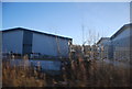
1

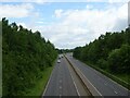
A6MARR
Works on the A6MARR with the existing A555 in the background.
Image: © Peter McDermott
Taken: 6 Aug 2016
0.17 miles
2
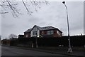
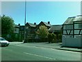
The Handforth Lodge
A bed and breakfast on the corner of Wilmslow Road and Spath Lane.
Image: © DS Pugh
Taken: 22 Mar 2017
0.18 miles
4
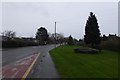
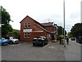
Grass verge and bus stop
Looking along Wilmslow Road approaching the junction with Spath Lane.
Image: © DS Pugh
Taken: 22 Mar 2017
0.20 miles
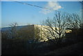
7

Manchester Airport Relief Road construction
The A6MARR under construction.
Image: © DS Pugh
Taken: 21 Mar 2017
0.23 miles
10
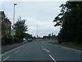
Wilmslow Road nears the A555 roundabout
Image: © Colin Pyle
Taken: 20 Jun 2014
0.24 miles