IMAGES TAKEN NEAR TO
Adlington Road, WILMSLOW, SK9 2BJ
Introduction
This page details the photographs taken nearby to Adlington Road, SK9 2BJ by members of the Geograph project.
The Geograph project started in 2005 with the aim of publishing, organising and preserving representative images for every square kilometre of Great Britain, Ireland and the Isle of Man.

There are currently over 7.5m images from over14,400 individuals and you can help contribute to the project by visiting https://www.geograph.org.uk
Image Map
Images are licensed for reuse under creativecommons.org/licenses/by-sa/2.0
Notes
- Clicking on the map will re-center to the selected point.
- The higher the marker number, the further away the image location is from the centre of the postcode.
Image Listing (4 Images Found)
Images are licensed for reuse under creativecommons.org/licenses/by-sa/2.0
Image
Details
Distance
1

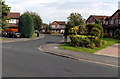
A5102 at Browns Lane, Dean Row
Nearly all the way into Wilmslow substantial houses flank the roadsides.
Image: © Peter Turner
Taken: 5 Mar 2012
0.22 miles
2

Dean Row Village Hall
The village hall at Dean Row. The plaque bears the legend WI2000, which I take to mean that the Women's Institute had a hand in its restoration in 2000A.D.
Image: © Roger May
Taken: 13 Nov 2005
0.22 miles
3
Lymewood Drive, Wilmslow
Viewed across Hazelwood Road.
Image: © Jaggery
Taken: 8 Sep 2014
0.24 miles
4
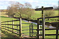
Bollin Valley Way fingerpost and kissing gate, Vardon Bridge
Image: © Peter Turner
Taken: 5 Mar 2012
0.25 miles