IMAGES TAKEN NEAR TO
Wilmslow Park North, WILMSLOW, SK9 2BH
Introduction
This page details the photographs taken nearby to Wilmslow Park North, SK9 2BH by members of the Geograph project.
The Geograph project started in 2005 with the aim of publishing, organising and preserving representative images for every square kilometre of Great Britain, Ireland and the Isle of Man.

There are currently over 7.5m images from over14,400 individuals and you can help contribute to the project by visiting https://www.geograph.org.uk
Image Map
Images are licensed for reuse under creativecommons.org/licenses/by-sa/2.0
Notes
- Clicking on the map will re-center to the selected point.
- The higher the marker number, the further away the image location is from the centre of the postcode.
Image Listing (7 Images Found)
Images are licensed for reuse under creativecommons.org/licenses/by-sa/2.0
Image
Details
Distance
1
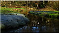
A bend in the R Bollin, W of Vardon Bridge, Wilmslow
Image: © Colin Park
Taken: 5 Jan 2017
0.11 miles
2
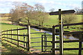
Bollin Valley Way fingerpost and kissing gate, Vardon Bridge
Image: © Peter Turner
Taken: 5 Mar 2012
0.12 miles
3
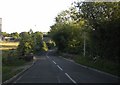
A5102 crossing Vardon Bridge over River Bollin
Image: © Peter Bond
Taken: 23 Jun 2011
0.15 miles
4
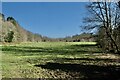
Water Meadows
Along the Bollin at Wilmslow Park
Image: © Anthony O'Neil
Taken: 19 Mar 2022
0.17 miles
5
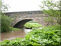
Vardon Bridge
Fine stone bridge over the River Bollin.
Image: © David Kitching
Taken: 20 May 2003
0.17 miles
6
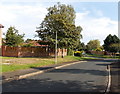
Birchwood Drive, Wilmslow
Viewed from Hazelwood Road.
Image: © Jaggery
Taken: 8 Sep 2014
0.21 miles
7
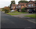
Hazelwood Road houses, Wilmslow
Between the Birchwood Drive junction behind the camera and the Thistledown Drive junction ahead.
Image: © Jaggery
Taken: 8 Sep 2014
0.23 miles