IMAGES TAKEN NEAR TO
Leaside Way, WILMSLOW, SK9 1EW
Introduction
This page details the photographs taken nearby to Leaside Way, SK9 1EW by members of the Geograph project.
The Geograph project started in 2005 with the aim of publishing, organising and preserving representative images for every square kilometre of Great Britain, Ireland and the Isle of Man.

There are currently over 7.5m images from over14,400 individuals and you can help contribute to the project by visiting https://www.geograph.org.uk
Image Map
Images are licensed for reuse under creativecommons.org/licenses/by-sa/2.0
Notes
- Clicking on the map will re-center to the selected point.
- The higher the marker number, the further away the image location is from the centre of the postcode.
Image Listing (35 Images Found)
Images are licensed for reuse under creativecommons.org/licenses/by-sa/2.0
Image
Details
Distance
1
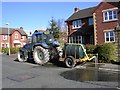
Fill 'er up!
A bowser being filled with water from a hydrant on Leaside Way, Wilmslow.
Image: © Keith Williamson
Taken: 1 Mar 2006
0.01 miles
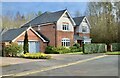
2

Around Wilmslow (8)
Detached House, Land Lane
Image: © Anthony O'Neil
Taken: 4 Mar 2022
0.03 miles
3
Prestbury Road
Looking eastwards along Prestbury Road, Wilmslow.
Image: © Keith Williamson
Taken: 1 Mar 2006
0.05 miles
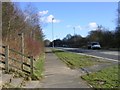
4
Around Wilmslow (11)
Steps to the A538
Image: © Anthony O'Neil
Taken: 4 Mar 2022
0.06 miles
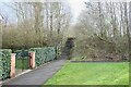
6

Around Wilmslow (7)
Track - Land Lane
Image: © Anthony O'Neil
Taken: 4 Mar 2022
0.06 miles
7

Around Wilmslow (6)
Track - Land Lane
Image: © Anthony O'Neil
Taken: 4 Mar 2022
0.07 miles
8

Around Wilmslow (9)
Houses in Thorngrove Road
Image: © Anthony O'Neil
Taken: 4 Mar 2022
0.08 miles
9
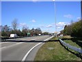
Wilmslow By-Pass
Looking N along the Wilmslow By-Pass (A34) to the east of Wilmslow, close to the junction with the A538, Prestbury Road.
Image: © Keith Williamson
Taken: 1 Mar 2006
0.09 miles
10
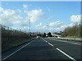
Wilmslow-Handforth by-pass looking north
Image: © Colin Pyle
Taken: 16 Apr 2013
0.10 miles