IMAGES TAKEN NEAR TO
Bowery Avenue, CHEADLE, SK8 6PR
Introduction
This page details the photographs taken nearby to Bowery Avenue, SK8 6PR by members of the Geograph project.
The Geograph project started in 2005 with the aim of publishing, organising and preserving representative images for every square kilometre of Great Britain, Ireland and the Isle of Man.

There are currently over 7.5m images from over14,400 individuals and you can help contribute to the project by visiting https://www.geograph.org.uk
Image Map
Images are licensed for reuse under creativecommons.org/licenses/by-sa/2.0
Notes
- Clicking on the map will re-center to the selected point.
- The higher the marker number, the further away the image location is from the centre of the postcode.
Image Listing (15 Images Found)
Images are licensed for reuse under creativecommons.org/licenses/by-sa/2.0
Image
Details
Distance
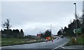
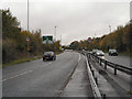
1
Roundabout on Kingsway South at Stanley Road
A "Steady Eddie" truck coming off the roundabout at its southern exit.
Cyclists are supposed to feel safe on the kerb side of that blue sign.
Image: © Geoff Royle
Taken: 6 Aug 2009
0.08 miles
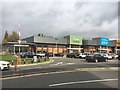
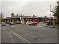
3
Stanley Green Retail Park
Retail park next to the A34 Wilmslow-Handforth Bypass and the A555 Manchester Airport Link Road.
Image: © David Dixon
Taken: 6 Nov 2012
0.10 miles
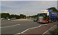
4
A34, Wilmslow-Handforth Bypass at Gilbent
Image: © David Dixon
Taken: 6 Nov 2012
0.11 miles
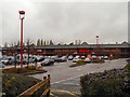
5
Stanley Green Retail Park
The entrance to the Stanley Green Retail Park.
Image: © David Dixon
Taken: 6 Nov 2012
0.12 miles
7

Stanley Green, Earl Road
Earl Road passing under the A555, Manchester Airport Link Road.
Image: © David Dixon
Taken: 6 Nov 2012
0.18 miles
8
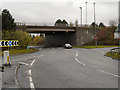
A34, Gilbent Roundabout
The junction of the A34 (Handforth and Wilmslow Bypass) with the A555 (Manchester Airport Ring Road).
Image: © David Dixon
Taken: 6 Nov 2012
0.18 miles
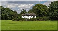
9
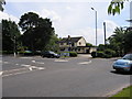
The Smithy
Public house at the junction of Gill Bent Road, Stanley Road and Grove Lane, Cheadle Hulme, Greater Manchester.
Image: © David Newton
Taken: 16 Jun 2009
0.21 miles