IMAGES TAKEN NEAR TO
Medina Close, CHEADLE, SK8 5SA
Introduction
This page details the photographs taken nearby to Medina Close, SK8 5SA by members of the Geograph project.
The Geograph project started in 2005 with the aim of publishing, organising and preserving representative images for every square kilometre of Great Britain, Ireland and the Isle of Man.

There are currently over 7.5m images from over14,400 individuals and you can help contribute to the project by visiting https://www.geograph.org.uk
Image Map (Loading...)


Getting Data...Please wait
Leaflet Map data © OpenStreetMap
Images are licensed for reuse under creativecommons.org/licenses/by-sa/2.0
Notes
- Clicking on the map will re-center to the selected point.
- The higher the marker number, the further away the image location is from the centre of the postcode.
Image Listing (8 Images Found)
Images are licensed for reuse under creativecommons.org/licenses/by-sa/2.0
Image
Details
Distance
1
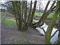
Micker Brook (Lady Brook)
Micker Brook (Lady Brook) - on the Ladybrook Valley Trail, Cheadle.
Image: © Mike Harris
Taken: 24 Feb 2007
0.07 miles
2
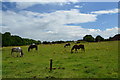
Green field site
Horses grazing in a field entirely surrounded by suburbia in Cheadle Hulme.
Image: © Peter Barr
Taken: 30 Jul 2012
0.12 miles
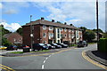
4
Micker Brook, a pub
And eatery, with a Lidl store in the background. On Councillor Lane, Cheadle Hulme, opposite Addswood Park.
Image: © Peter Barr
Taken: 30 Jul 2012
0.17 miles
5

Councillor Lane Resource Centre
National Health Service Resource Centre on Councillor Lane at Adswood, Stockport.
Image: © Roger May
Taken: 13 Nov 2005
0.18 miles
6
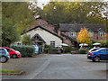
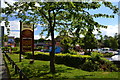
March Hare
The March Hare restaurant and bar at the end of Image
Image: © David Dixon
Taken: 29 Sep 2011
0.20 miles
7
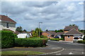
Block of flats, Warwick Close
Off Grange Avenue, Cheadle Hulme.
Image: © Peter Barr
Taken: 30 Jul 2012
0.22 miles
8
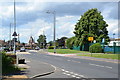
Councillor Lane
At the junction with Calderbrook Drive. Outside Ladybridge Primary School.
Image: © Peter Barr
Taken: 30 Jul 2012
0.22 miles