IMAGES TAKEN NEAR TO
Twining Brook Road, CHEADLE, SK8 5PU
Introduction
This page details the photographs taken nearby to Twining Brook Road, SK8 5PU by members of the Geograph project.
The Geograph project started in 2005 with the aim of publishing, organising and preserving representative images for every square kilometre of Great Britain, Ireland and the Isle of Man.

There are currently over 7.5m images from over14,400 individuals and you can help contribute to the project by visiting https://www.geograph.org.uk
Image Map
Images are licensed for reuse under creativecommons.org/licenses/by-sa/2.0
Notes
- Clicking on the map will re-center to the selected point.
- The higher the marker number, the further away the image location is from the centre of the postcode.
Image Listing (31 Images Found)
Images are licensed for reuse under creativecommons.org/licenses/by-sa/2.0
Image
Details
Distance

4
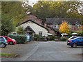
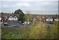
March Hare
The March Hare restaurant and bar at the end of Image
Image: © David Dixon
Taken: 29 Sep 2011
0.13 miles
5
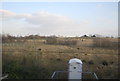
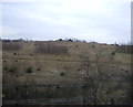
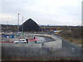
Gas flare, Ladybridge landfill site
Image shows the waste recycling centre the other side of Tenement Lane, built on the site of a landfilled quarry. The gas here is therefore probably methane from the landfill.
Image: © Stephen Craven
Taken: 27 Dec 2021
0.15 miles
7
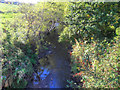
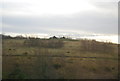
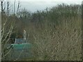
Lady Brook
Lady Brook (also shown as Micker Brook on some maps), seen from Lady Bridge.
Image: © David Dixon
Taken: 29 Sep 2011
0.17 miles