IMAGES TAKEN NEAR TO
Betleymere Road, CHEADLE, SK8 5HT
Introduction
This page details the photographs taken nearby to Betleymere Road, SK8 5HT by members of the Geograph project.
The Geograph project started in 2005 with the aim of publishing, organising and preserving representative images for every square kilometre of Great Britain, Ireland and the Isle of Man.

There are currently over 7.5m images from over14,400 individuals and you can help contribute to the project by visiting https://www.geograph.org.uk
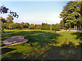
Image Map
Images are licensed for reuse under creativecommons.org/licenses/by-sa/2.0
Notes
- Clicking on the map will re-center to the selected point.
- The higher the marker number, the further away the image location is from the centre of the postcode.
Image Listing (9 Images Found)
Images are licensed for reuse under creativecommons.org/licenses/by-sa/2.0
Image
Details
Distance
3
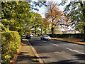
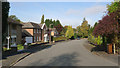
Cheadle Road (A5149)
Cheadle Road, passing the Cheadle and Marple Sixth Form College (to the right).
Image: © David Dixon
Taken: 29 Sep 2011
0.15 miles
4
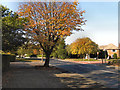
Cheadle Road (A5149)
The road between Cheadle Hulme and Cheadle.
Image: © David Dixon
Taken: 29 Sep 2011
0.15 miles
5
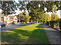
Cheadle Road (A5149)
The road between Cheadle and Cheadle Hulme, passing Cheadle and Marple Sixth Form College (behind the hedge).
Image: © David Dixon
Taken: 29 Sep 2011
0.16 miles
6
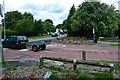
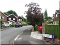
Cheadle Road, junction with Orrishmere Road
20 mph sign on road due to proximity of a school.
Image: © Peter Barr
Taken: 30 Jul 2012
0.18 miles