IMAGES TAKEN NEAR TO
Grasmere Road, CHEADLE, SK8 4RG
Introduction
This page details the photographs taken nearby to Grasmere Road, SK8 4RG by members of the Geograph project.
The Geograph project started in 2005 with the aim of publishing, organising and preserving representative images for every square kilometre of Great Britain, Ireland and the Isle of Man.

There are currently over 7.5m images from over14,400 individuals and you can help contribute to the project by visiting https://www.geograph.org.uk
Image Map
Images are licensed for reuse under creativecommons.org/licenses/by-sa/2.0
Notes
- Clicking on the map will re-center to the selected point.
- The higher the marker number, the further away the image location is from the centre of the postcode.
Image Listing (8 Images Found)
Images are licensed for reuse under creativecommons.org/licenses/by-sa/2.0
Image
Details
Distance
2
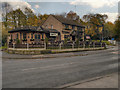
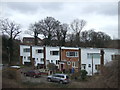
High Grove
Pub/restaurant on Silverdale Road, between Gatley and Heald Green.
Image: © David Dixon
Taken: 2 Nov 2012
0.16 miles
4
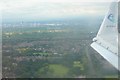
Flying over the Styal Line
Air Adria flight from Ljubljana in Slovenia inbound to Manchester Airport runway 23R
Image: © Richard Cooke
Taken: 7 Aug 2010
0.21 miles
5
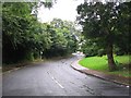
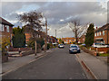
Road in Gatley
This picture was taken from SJ851872 looking SSW.
Image: © Dave Smethurst
Taken: 10 Sep 2005
0.21 miles
7
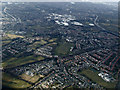
Gatley from the air
Scholes Park athletics track can be seen in the centre of the photo.
Image: © Thomas Nugent
Taken: 2 Apr 2013
0.22 miles
8
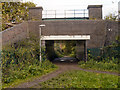
Underpass to Borrowdale Avenue
Bridge carrying the Manchester Airport railway line over the footpath leading to Borrowdale Avenue.
Image: © David Dixon
Taken: 2 Nov 2012
0.23 miles