IMAGES TAKEN NEAR TO
Carlton Drive, CHEADLE, SK8 4DY
Introduction
This page details the photographs taken nearby to Carlton Drive, SK8 4DY by members of the Geograph project.
The Geograph project started in 2005 with the aim of publishing, organising and preserving representative images for every square kilometre of Great Britain, Ireland and the Isle of Man.

There are currently over 7.5m images from over14,400 individuals and you can help contribute to the project by visiting https://www.geograph.org.uk
Image Map
Images are licensed for reuse under creativecommons.org/licenses/by-sa/2.0
Notes
- Clicking on the map will re-center to the selected point.
- The higher the marker number, the further away the image location is from the centre of the postcode.
Image Listing (5 Images Found)
Images are licensed for reuse under creativecommons.org/licenses/by-sa/2.0
Image
Details
Distance
1
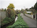
Gatley Brook, Cheshire
And the imaginatively named Brookside Road
Image: © Nigel Thompson
Taken: 13 Nov 2012
0.17 miles
3
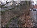
Gatley Brook
Looking downstream to the east by Church Road, Gatley
Image: © Keith Williamson
Taken: 1 Feb 2006
0.22 miles
4
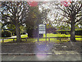
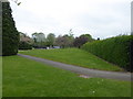
Gatley Recreation Ground
The entrance to the Gatley Recreation Ground (informally known as Gatley Park), a small area between Church Road and Northenden Road.
Image: © David Dixon
Taken: 27 Sep 2011
0.24 miles