IMAGES TAKEN NEAR TO
Lomond Road, CHEADLE, SK8 3TZ
Introduction
This page details the photographs taken nearby to Lomond Road, SK8 3TZ by members of the Geograph project.
The Geograph project started in 2005 with the aim of publishing, organising and preserving representative images for every square kilometre of Great Britain, Ireland and the Isle of Man.

There are currently over 7.5m images from over14,400 individuals and you can help contribute to the project by visiting https://www.geograph.org.uk
Image Map
Images are licensed for reuse under creativecommons.org/licenses/by-sa/2.0
Notes
- Clicking on the map will re-center to the selected point.
- The higher the marker number, the further away the image location is from the centre of the postcode.
Image Listing (7 Images Found)
Images are licensed for reuse under creativecommons.org/licenses/by-sa/2.0
Image
Details
Distance
1
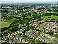
Styal Road from the air
On approach to Manchester Airport from the north east.
Image: © Thomas Nugent
Taken: 13 Jun 2014
0.17 miles
3
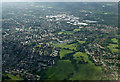
Peel Hall from the air
Shartson Industrial Area can be seen in the distance.
Image: © Thomas Nugent
Taken: 16 Jun 2014
0.21 miles
4
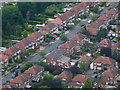
Semi-Detached Houses at Heald Green
Aerial photograph taken on the descent to Manchester Airport.
Image: © David Dixon
Taken: 16 Jul 2016
0.22 miles
5
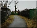
Footbridge over the Styal Line. Heald Green
The bridge connects Rose Vale Park and Motcombe Road.
Image: © Benjamin Shaw
Taken: 10 Jan 2021
0.23 miles
6
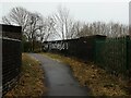
Footbridge over the Styal Line. Heald Green
The bridge connects Rose Vale Park and Motcombe Road.
Image: © Benjamin Shaw
Taken: 10 Jan 2021
0.23 miles
7
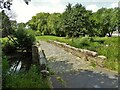
Moat Bridge
View towards the site of Peel Hall which was a moated site. It is now the centre of Peel Hall Park.
Image: © Kevin Waterhouse
Taken: 25 Jun 2023
0.24 miles