IMAGES TAKEN NEAR TO
Lymm Walk, CHEADLE, SK8 2NA
Introduction
This page details the photographs taken nearby to Lymm Walk, SK8 2NA by members of the Geograph project.
The Geograph project started in 2005 with the aim of publishing, organising and preserving representative images for every square kilometre of Great Britain, Ireland and the Isle of Man.

There are currently over 7.5m images from over14,400 individuals and you can help contribute to the project by visiting https://www.geograph.org.uk
Image Map
Images are licensed for reuse under creativecommons.org/licenses/by-sa/2.0
Notes
- Clicking on the map will re-center to the selected point.
- The higher the marker number, the further away the image location is from the centre of the postcode.
Image Listing (6 Images Found)
Images are licensed for reuse under creativecommons.org/licenses/by-sa/2.0
Image
Details
Distance
1
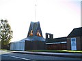
All Hallows
Parish church on Councillor Lane, Cheadle.
Image: © Roger May
Taken: 13 Nov 2005
0.08 miles
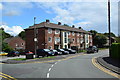
3
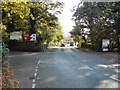
Councillor Lane
At the junction with Calderbrook Drive. Outside Ladybridge Primary School.
Image: © Peter Barr
Taken: 30 Jul 2012
0.21 miles
5
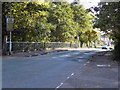
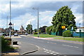
Queen's Road, Cheadle
The bridge over Micker Brook.
Image: © David Dixon
Taken: 29 Sep 2011
0.24 miles
6
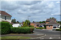
Block of flats, Warwick Close
Off Grange Avenue, Cheadle Hulme.
Image: © Peter Barr
Taken: 30 Jul 2012
0.25 miles