IMAGES TAKEN NEAR TO
Aber Road, CHEADLE, SK8 2ES

Introduction

This page details the photographs taken nearby to Aber Road, SK8 2ES by members of the Geograph project.

The Geograph project started in 2005 with the aim of publishing, organising and preserving representative images for every square kilometre of Great Britain, Ireland and the Isle of Man.

There are currently over 7.5m images from over14,400 individuals and you can help contribute to the project by visiting https://www.geograph.org.uk

Image Map


Images are licensed for reuse under creativecommons.org/licenses/by-sa/2.0
Notes
  • Clicking on the map will re-center to the selected point.
  • The higher the marker number, the further away the image location is from the centre of the postcode.

Image Listing (4 Images Found)

Images are licensed for reuse under creativecommons.org/licenses/by-sa/2.0
Image
Details
Distance
1
Residential Estate at Cheadle Heath
Aerial view taken on the descent towards Manchester Airport.
Image: © David Dixon Taken: 16 Jul 2016
0.20 miles
2
Vacant Warehousing
A huge vacant plot on Birdhall Lane previously occupied by the distribution warehouses of Fowler Welch.
Image: © Gerald England Taken: 6 Aug 2012
0.23 miles
3
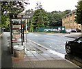
Bus stop on Birdhall Lane
Whilst most vehicles driving past were far enough into the road to miss the puddle by the bus stop, about one in ten drove close enough to hit more than the edge of puddle sending a huge splash of water straight into the bus shelter, which is why I was here taking this photograph rather than standing in the shelter having been showered twice.
Image: © Gerald England Taken: 6 Aug 2012
0.25 miles
4
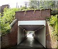
Birdhall Lane Underpass
Where the road goes under the former Cheshire Lines Committee railway there is a separate underpass for pedestrians to avoid the busy road bridge.
Image: © Gerald England Taken: 6 Aug 2012
0.25 miles