IMAGES TAKEN NEAR TO
Deane Avenue, CHEADLE, SK8 2DW
Introduction
This page details the photographs taken nearby to Deane Avenue, SK8 2DW by members of the Geograph project.
The Geograph project started in 2005 with the aim of publishing, organising and preserving representative images for every square kilometre of Great Britain, Ireland and the Isle of Man.

There are currently over 7.5m images from over14,400 individuals and you can help contribute to the project by visiting https://www.geograph.org.uk
Image Map
Images are licensed for reuse under creativecommons.org/licenses/by-sa/2.0
Notes
- Clicking on the map will re-center to the selected point.
- The higher the marker number, the further away the image location is from the centre of the postcode.
Image Listing (3 Images Found)
Images are licensed for reuse under creativecommons.org/licenses/by-sa/2.0
Image
Details
Distance
1
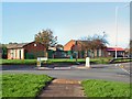
Meadowbank Primary School
At the intersection of Demmings Lane and Councillor Lane, Cheadle.
Image: © Roger May
Taken: 13 Nov 2005
0.20 miles
2
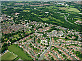
Cheadle from the air
Abney Hall and the M60 motorway can be seen in the top half of the photo.
Image: © Thomas Nugent
Taken: 13 Jun 2014
0.21 miles
3
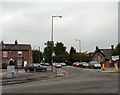
Councillor Lane
The road from Cheadle to Adswood.
Image: © Gerald England
Taken: 27 Jun 2009
0.23 miles