IMAGES TAKEN NEAR TO
Kingsway, CHEADLE, SK8 1QU
Introduction
This page details the photographs taken nearby to Kingsway, SK8 1QU by members of the Geograph project.
The Geograph project started in 2005 with the aim of publishing, organising and preserving representative images for every square kilometre of Great Britain, Ireland and the Isle of Man.

There are currently over 7.5m images from over14,400 individuals and you can help contribute to the project by visiting https://www.geograph.org.uk
Image Map
Images are licensed for reuse under creativecommons.org/licenses/by-sa/2.0
Notes
- Clicking on the map will re-center to the selected point.
- The higher the marker number, the further away the image location is from the centre of the postcode.
Image Listing (33 Images Found)
Images are licensed for reuse under creativecommons.org/licenses/by-sa/2.0
Image
Details
Distance
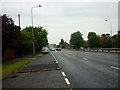
2
Junction of the A560 and A34 near Cheadle, Greater Manchester
Image: © Steve Fareham
Taken: 23 May 2012
0.08 miles
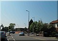
4
Northenden Road, Cheadle
At the junction with Delamere Road.
Image: © Peter Barr
Taken: 27 Feb 2013
0.15 miles
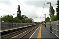
5
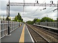
Gatley Station
Looking North towards Manchester.
Image: © Gerald England
Taken: 24 Jun 2010
0.18 miles
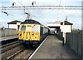
6
Gatley Station
The Southbound platform.
Image: © Gerald England
Taken: 24 Jun 2010
0.18 miles
7
Gatley Station
Looking North towards Manchester.
Image: © Gerald England
Taken: 24 Jun 2010
0.18 miles
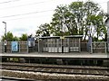
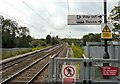
8
Gatley station - up side
Train calling on an Altrincham to Alderley Edge via Styal working.
Image: © Peter Whatley
Taken: 25 Mar 1989
0.18 miles
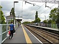
9
Waiting for the Manchester Train
Looking South at Gatley Station.
Image: © Gerald England
Taken: 24 Jun 2010
0.18 miles
10
Gatley Station
Looking South towards Manchester Airport.
Image: © Gerald England
Taken: 24 Jun 2010
0.18 miles