IMAGES TAKEN NEAR TO
Brook Lane, STOCKPORT, SK7 6LT
Introduction
This page details the photographs taken nearby to Brook Lane, SK7 6LT by members of the Geograph project.
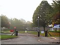
The Geograph project started in 2005 with the aim of publishing, organising and preserving representative images for every square kilometre of Great Britain, Ireland and the Isle of Man.

There are currently over 7.5m images from over14,400 individuals and you can help contribute to the project by visiting https://www.geograph.org.uk
Image Map
Images are licensed for reuse under creativecommons.org/licenses/by-sa/2.0
Notes
- Clicking on the map will re-center to the selected point.
- The higher the marker number, the further away the image location is from the centre of the postcode.
Image Listing (12 Images Found)
Images are licensed for reuse under creativecommons.org/licenses/by-sa/2.0
Image
Details
Distance
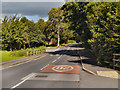
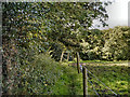
2
Path from Torkington Road to Taunton Close
On the eastern edge of Hazel Grove.
Image: © Christine Johnstone
Taken: 30 Nov 2021
0.08 miles
3
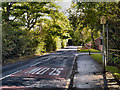
Torkington
Torkington Road, passing Torkington Manor.
Image: © David Dixon
Taken: 18 Sep 2012
0.10 miles
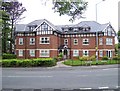
4
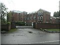
Torkington Manor
By the 1930s this Victorian building had been split into two residences - Manor House and Harefield. It has since been converted into numerous apartments.
Image: © Christine Johnstone
Taken: 30 Nov 2021
0.11 miles
5
Torkington Primary School
Backing onto fields at Hazel grove Golf Club, this primary school is in an idyllic location adjacent to the meandering Ochrelay brook.
Image: © Roger May
Taken: 16 Oct 2005
0.11 miles
6
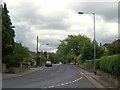
Sandown Road from Taunton Close
At the eastern edge of Hazel Grove.
Image: © Christine Johnstone
Taken: 30 Nov 2021
0.13 miles
8
Torkington Road, Hazel Grove
Looking away from bend in Torkington Road with junction of Highfield Road.
Image: © Carl Farnell
Taken: 19 Jun 2011
0.14 miles
9
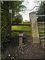
Path to Broadoak Farm
Path from Torkington Road.
Image: © David Dixon
Taken: 18 Sep 2012
0.19 miles
10
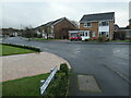
New development, Hazel Grove
Looking across the Torkington Road & Offerton Road junction.
On this site was a NHS property, (clinic?).
Image: © Carl Farnell
Taken: 19 Jun 2011
0.24 miles