IMAGES TAKEN NEAR TO
Gower Avenue, STOCKPORT, SK7 5AL
Introduction
This page details the photographs taken nearby to Gower Avenue, SK7 5AL by members of the Geograph project.
The Geograph project started in 2005 with the aim of publishing, organising and preserving representative images for every square kilometre of Great Britain, Ireland and the Isle of Man.

There are currently over 7.5m images from over14,400 individuals and you can help contribute to the project by visiting https://www.geograph.org.uk
Image Map
Images are licensed for reuse under creativecommons.org/licenses/by-sa/2.0
Notes
- Clicking on the map will re-center to the selected point.
- The higher the marker number, the further away the image location is from the centre of the postcode.
Image Listing (16 Images Found)
Images are licensed for reuse under creativecommons.org/licenses/by-sa/2.0
Image
Details
Distance
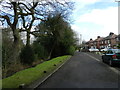
1
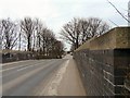
Bramhall Moor Road
The bridge over the Manchester to Buxton railway line.
Image: © Gerald England
Taken: 18 Mar 2010
0.09 miles
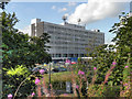
5
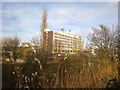
Stepping Hill Hospital
Viewed from Bramhall Moor Lane on the bridge over the railway from Stockport to Buxton.
Image: © Bill Boaden
Taken: 29 Nov 2010
0.12 miles
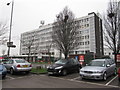
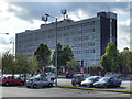
9
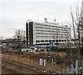
Stepping Hill Hospital
Viewed from the railway bridge on Bramhall Moor Road.
Image: © Gerald England
Taken: 18 Mar 2010
0.20 miles
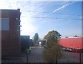
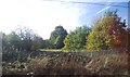
10
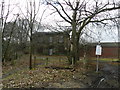
Boarded-up, stone-built house
At the end of Barlow's Lane South, on property called Mirrlees Field owned by MAN Diesel and Turbo UK Ltd, through which run a couple of footpaths.
Image: © Peter Barr
Taken: 15 Feb 2013
0.20 miles