IMAGES TAKEN NEAR TO
Clarendon Road, STOCKPORT, SK7 4NS
Introduction
This page details the photographs taken nearby to Clarendon Road, SK7 4NS by members of the Geograph project.
The Geograph project started in 2005 with the aim of publishing, organising and preserving representative images for every square kilometre of Great Britain, Ireland and the Isle of Man.

There are currently over 7.5m images from over14,400 individuals and you can help contribute to the project by visiting https://www.geograph.org.uk
Image Map
Images are licensed for reuse under creativecommons.org/licenses/by-sa/2.0
Notes
- Clicking on the map will re-center to the selected point.
- The higher the marker number, the further away the image location is from the centre of the postcode.
Image Listing (7 Images Found)
Images are licensed for reuse under creativecommons.org/licenses/by-sa/2.0
Image
Details
Distance
1
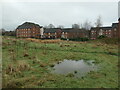
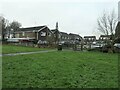
Housing, Cooper Street, Hazel Grove
Built on the site of Wellington cotton mill. The dam of the former mill pond is at the left edge of the picture. The waterlogged ground in the foreground is on the site of a small pond mapped in 1872.
Image: © Christine Johnstone
Taken: 30 Nov 2021
0.12 miles
2
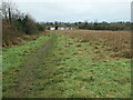
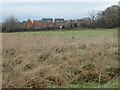
Path heading west towards Hazel Grove
Not a public footpath, but well-used. The terrace of white houses are in nelson Street.
Image: © Christine Johnstone
Taken: 30 Nov 2021
0.13 miles
3
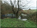
Waterlogged public footpath, Offerton
Pat of the Cown Edge Way, after a thaw. A dry detour is available.
Image: © Christine Johnstone
Taken: 30 Nov 2021
0.13 miles
4
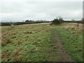
Footpaths on the east bank of Poise Brook
The one on the left/north is a public footpath, part of the Cown Edge Way. The one on the right/south is neither. Both are well used.
Image: © Christine Johnstone
Taken: 30 Nov 2021
0.16 miles
5
Houses on Peregrine Road, Offerton
Seen from Peregrine Park. All the roads in this development are named after birds.
Image: © Christine Johnstone
Taken: 30 Nov 2021
0.19 miles
6
Housing, Kingfisher Road, Offerton
Looking north from Cown Edge Way.
Image: © Christine Johnstone
Taken: 30 Nov 2021
0.21 miles
7
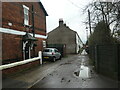
Terraced houses, Nelson Street, Hazel Grove
Already built by 1872, when they were described as being in Bosdenfold, not Hazel Grove. The residents probably worked in the nearby [and long-gone] Wellington cotton mill.
Image: © Christine Johnstone
Taken: 30 Nov 2021
0.23 miles