IMAGES TAKEN NEAR TO
The Dingle, STOCKPORT, SK7 3NF
Introduction
This page details the photographs taken nearby to The Dingle, SK7 3NF by members of the Geograph project.
The Geograph project started in 2005 with the aim of publishing, organising and preserving representative images for every square kilometre of Great Britain, Ireland and the Isle of Man.

There are currently over 7.5m images from over14,400 individuals and you can help contribute to the project by visiting https://www.geograph.org.uk
Image Map
Images are licensed for reuse under creativecommons.org/licenses/by-sa/2.0
Notes
- Clicking on the map will re-center to the selected point.
- The higher the marker number, the further away the image location is from the centre of the postcode.
Image Listing (6 Images Found)
Images are licensed for reuse under creativecommons.org/licenses/by-sa/2.0
Image
Details
Distance
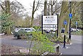
1
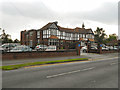
Bramhall Park Golf Club, Manor Road, Cheadle Hulme
Image: © David Dixon
Taken: 24 Aug 2011
0.22 miles
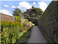
3
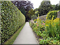
Bramall Hall Garden
Part of the 70 acres of parkland with lakes, woodland, and gardens surrounding Image
Image: © David Dixon
Taken: 24 Aug 2011
0.24 miles
5
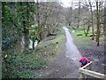
Lady Brook in Bramhall Park
Lady Brook and Bramhall Park from the steps down from Bramhall Park Road.
Image: © Mike Harris
Taken: 24 Feb 2007
0.24 miles