IMAGES TAKEN NEAR TO
Bridge Lane, STOCKPORT, SK7 3AS
Introduction
This page details the photographs taken nearby to Bridge Lane, SK7 3AS by members of the Geograph project.
The Geograph project started in 2005 with the aim of publishing, organising and preserving representative images for every square kilometre of Great Britain, Ireland and the Isle of Man.

There are currently over 7.5m images from over14,400 individuals and you can help contribute to the project by visiting https://www.geograph.org.uk
Image Map
Images are licensed for reuse under creativecommons.org/licenses/by-sa/2.0
Notes
- Clicking on the map will re-center to the selected point.
- The higher the marker number, the further away the image location is from the centre of the postcode.
Image Listing (10 Images Found)
Images are licensed for reuse under creativecommons.org/licenses/by-sa/2.0
Image
Details
Distance
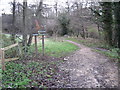
4
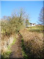
Path to Wall Bank Farm
Path from Lady Brook to Bridge Lane (A5143) via Wall Bank Road.
Image: © John Topping
Taken: 3 Apr 2013
0.22 miles
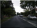
5
Footpath through Happy Valley, Bramhall
Image: © Chris Wimbush
Taken: 25 Nov 2010
0.22 miles
6
Path by Lady Brook
In the Happy Valley Local Nature Reserve
Image: © Kevin Waterhouse
Taken: 18 Jul 2024
0.24 miles
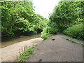
7
Lady Brook at Happy Valley
The Lady Brook, at the Happy Valley Nature Reserve.
Image: © David Dixon
Taken: 23 Aug 2011
0.24 miles
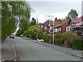
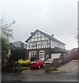
9
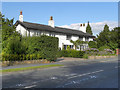
Bramhall Moor Lane
White-painted cottages on Bramhall Moor Lane.
Image: © David Dixon
Taken: 23 Aug 2011
0.24 miles
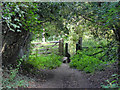
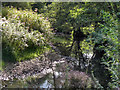
10
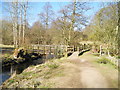
Footbridge, Lady Brook
Lady Brook Valley Interest Trail.
Image: © John Topping
Taken: 3 Apr 2013
0.24 miles