IMAGES TAKEN NEAR TO
Southern Close, STOCKPORT, SK7 3AJ
Introduction
This page details the photographs taken nearby to Southern Close, SK7 3AJ by members of the Geograph project.
The Geograph project started in 2005 with the aim of publishing, organising and preserving representative images for every square kilometre of Great Britain, Ireland and the Isle of Man.

There are currently over 7.5m images from over14,400 individuals and you can help contribute to the project by visiting https://www.geograph.org.uk
Image Map
Images are licensed for reuse under creativecommons.org/licenses/by-sa/2.0
Notes
- Clicking on the map will re-center to the selected point.
- The higher the marker number, the further away the image location is from the centre of the postcode.
Image Listing (5 Images Found)
Images are licensed for reuse under creativecommons.org/licenses/by-sa/2.0
Image
Details
Distance
4
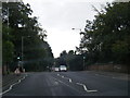
Approaching Valley Road from Happy Valley
The path which has followed Lady Brook through the local nature reserve, Happy Valley, is about to exit at Valley Road close to Bridge Lane.
Image: © Kevin Waterhouse
Taken: 18 Jul 2024
0.17 miles
5
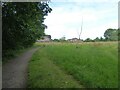
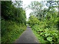
Path to Bridge Lane
The path that starts in Woods Moor and follows an unnamed stream is on open land near some housing at the end of Grange Road. The path eventually reaches Bridge Lane and the stream joins Lady Brook.
Image: © Kevin Waterhouse
Taken: 18 Jul 2024
0.24 miles