IMAGES TAKEN NEAR TO
Pine Road, STOCKPORT, SK7 2JN
Introduction
This page details the photographs taken nearby to Pine Road, SK7 2JN by members of the Geograph project.
The Geograph project started in 2005 with the aim of publishing, organising and preserving representative images for every square kilometre of Great Britain, Ireland and the Isle of Man.

There are currently over 7.5m images from over14,400 individuals and you can help contribute to the project by visiting https://www.geograph.org.uk
Image Map
Images are licensed for reuse under creativecommons.org/licenses/by-sa/2.0
Notes
- Clicking on the map will re-center to the selected point.
- The higher the marker number, the further away the image location is from the centre of the postcode.
Image Listing (12 Images Found)
Images are licensed for reuse under creativecommons.org/licenses/by-sa/2.0
Image
Details
Distance
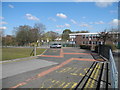
2
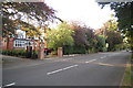
Seal Road, Bramhall
Viewed from the school bus exit junction (Bramhall High School).
Image: © John Topping
Taken: 3 Apr 2013
0.16 miles
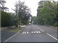
3
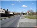
Colwyn Road, Bramhall
Looking roughly east along this typical road to the north of Bramhall town centre.
Image: © Keith Williamson
Taken: 1 Mar 2006
0.17 miles
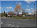
4
Bramhall High School
School bus parking area.
Image: © John Topping
Taken: 3 Apr 2013
0.18 miles
5
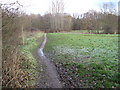
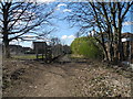
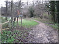
Footpath towards Lady Brook, Bramhall
Image: © Chris Wimbush
Taken: 25 Nov 2010
0.18 miles
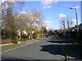
6
Bramhall High School
Viewed from Seal Road.
Image: © John Topping
Taken: 3 Apr 2013
0.19 miles
8
Footpath through Happy Valley, Bramhall
Image: © Chris Wimbush
Taken: 25 Nov 2010
0.21 miles
9
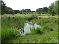
Pond in open space
Part of the Happy Valley Local Nature Reserve, south of Lady Brook
Image: © Kevin Waterhouse
Taken: 18 Jul 2024
0.22 miles