IMAGES TAKEN NEAR TO
Pownall Avenue, STOCKPORT, SK7 2HE
Introduction
This page details the photographs taken nearby to Pownall Avenue, SK7 2HE by members of the Geograph project.
The Geograph project started in 2005 with the aim of publishing, organising and preserving representative images for every square kilometre of Great Britain, Ireland and the Isle of Man.

There are currently over 7.5m images from over14,400 individuals and you can help contribute to the project by visiting https://www.geograph.org.uk
Image Map (Loading...)


Getting Data...Please wait
Leaflet Map data © OpenStreetMap
Images are licensed for reuse under creativecommons.org/licenses/by-sa/2.0
Notes
- Clicking on the map will re-center to the selected point.
- The higher the marker number, the further away the image location is from the centre of the postcode.
Image Listing (7 Images Found)
Images are licensed for reuse under creativecommons.org/licenses/by-sa/2.0
Image
Details
Distance
2
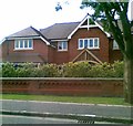
House on Pownall Avenue, Bramhall
Imposing gates and watchful eagles (probably containing the CCTV cameras).
Image: © Peter Barr
Taken: 30 Jul 2012
0.06 miles
3
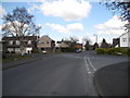
Seal Road, Bramhall
At the junction with Ainsdale Close (left) and Lytham Drive on the right.
Image: © John Topping
Taken: 3 Apr 2013
0.19 miles
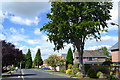
4
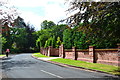
Ladythorn Crescent,Bramhall
A horse and rider on a tree lined road, with a fine brick wall.
Image: © Peter Barr
Taken: 30 Jul 2012
0.21 miles
5
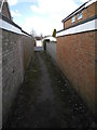
Alley way to Camberley Close from Dairyground
Image: © John Topping
Taken: 3 Apr 2013
0.22 miles
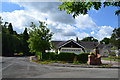
6
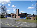
Ladybrook Primary School
Gleneagles, Bramhall.
Image: © John Topping
Taken: 3 Apr 2013
0.23 miles
7
Detached houses on Northcote Road, Bramhall
Image: © Peter Barr
Taken: 30 Jul 2012
0.24 miles