IMAGES TAKEN NEAR TO
Severn Drive, STOCKPORT, SK7 1EX
Introduction
This page details the photographs taken nearby to Severn Drive, SK7 1EX by members of the Geograph project.
The Geograph project started in 2005 with the aim of publishing, organising and preserving representative images for every square kilometre of Great Britain, Ireland and the Isle of Man.

There are currently over 7.5m images from over14,400 individuals and you can help contribute to the project by visiting https://www.geograph.org.uk
Image Map
Images are licensed for reuse under creativecommons.org/licenses/by-sa/2.0
Notes
- Clicking on the map will re-center to the selected point.
- The higher the marker number, the further away the image location is from the centre of the postcode.
Image Listing (6 Images Found)
Images are licensed for reuse under creativecommons.org/licenses/by-sa/2.0
Image
Details
Distance
1
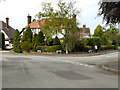
Elmsway/Thornway
The junction of Elmsway and Thornway
Image: © David Dixon
Taken: 24 Aug 2011
0.18 miles
2
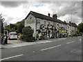
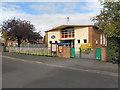
The Bottle Stop
An eye-catching off licence on Acre Lane (B5094) at Kitt's Moss.
Image: © David Dixon
Taken: 24 Aug 2011
0.19 miles

5
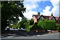
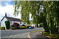
Kitt's Moss Lane
In the Kitt's Moss area of Bramhall,
Image: © Peter Barr
Taken: 30 Jul 2012
0.24 miles