IMAGES TAKEN NEAR TO
Croxton Close, STOCKPORT, SK6 7RQ
Introduction
This page details the photographs taken nearby to Croxton Close, SK6 7RQ by members of the Geograph project.
The Geograph project started in 2005 with the aim of publishing, organising and preserving representative images for every square kilometre of Great Britain, Ireland and the Isle of Man.

There are currently over 7.5m images from over14,400 individuals and you can help contribute to the project by visiting https://www.geograph.org.uk
Image Map (Loading...)


Getting Data...Please wait
Leaflet Map data © OpenStreetMap
Images are licensed for reuse under creativecommons.org/licenses/by-sa/2.0
Notes
- Clicking on the map will re-center to the selected point.
- The higher the marker number, the further away the image location is from the centre of the postcode.
Image Listing (8 Images Found)
Images are licensed for reuse under creativecommons.org/licenses/by-sa/2.0
Image
Details
Distance
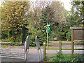
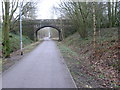
2
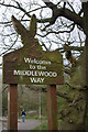
Welcome to the Middlewood Way
The Middlewood Way is a cycleway and footpath which follows the course of the Macclesfield - Marple railway, closed in 1970.
Image: © Stephen McKay
Taken: 30 Mar 2007
0.18 miles
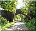
3
Throstle Grove Bridge
Over the former Macclesfield to Marple railway.
Image: © Gerald England
Taken: 12 May 2009
0.20 miles
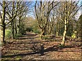
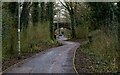
6
Middlewood Way
A cycleway and footpath following the line of the Macclesfield to Marple railway, closed in 1970.
Image: © Gerald England
Taken: 12 May 2009
0.21 miles
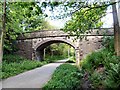
7
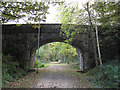
Throstle Grove Bridge over the Middlewood Way
Throstle Grove is a road to the east of here, but only a footpath from where it meets the old railway line.
Image: © Stephen Craven
Taken: 5 Nov 2016
0.22 miles