IMAGES TAKEN NEAR TO
Boucher Street, STOCKPORT, SK6 7RL
Introduction
This page details the photographs taken nearby to Boucher Street, SK6 7RL by members of the Geograph project.
The Geograph project started in 2005 with the aim of publishing, organising and preserving representative images for every square kilometre of Great Britain, Ireland and the Isle of Man.

There are currently over 7.5m images from over14,400 individuals and you can help contribute to the project by visiting https://www.geograph.org.uk
Image Map
Images are licensed for reuse under creativecommons.org/licenses/by-sa/2.0
Notes
- Clicking on the map will re-center to the selected point.
- The higher the marker number, the further away the image location is from the centre of the postcode.
Image Listing (38 Images Found)
Images are licensed for reuse under creativecommons.org/licenses/by-sa/2.0
Image
Details
Distance
1
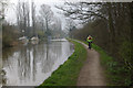
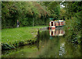
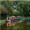
Macclesfield Canal, Marple
A cyclist rides along the towpath near the northern end of the 26-mile canal which runs south from here to Kidsgrove.
Image: © Stephen McKay
Taken: 30 Mar 2007
0.18 miles
2
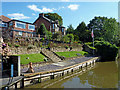
The Narrows
Possibly where an access bridge was located at one time.
Image: © Peter Turner
Taken: 16 Feb 2013
0.18 miles
3
Marple - former Albert Schools building
More recently occupied by the protective clothing company E&E Overalls.
Image: © Dave Bevis
Taken: 15 Mar 2014
0.19 miles
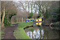
4
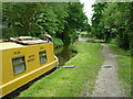
Quiet moorings
In Marple, opposite some private moorings, on the Macclesfield Canal.
Image: © Peter Barr
Taken: 28 Jul 2011
0.19 miles
5
Macclesfield Canal in Marple, Cheshire
This is the position of a former swing bridge, but doesn't show in the current bridge numbering scheme. There is housing on both sides of the canal now. 1871 OS maps (revised in 1907) show the existence of the bridge. Can anyone suggest when it was removed?
Image: © Roger D Kidd
Taken: 5 Sep 2014
0.19 miles
6
The Macclesfield Canal in Marple ...
.... or should that be Peckham?
Image: © Graham Hogg
Taken: 16 May 2011
0.20 miles
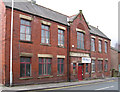
7
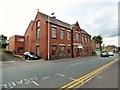
Former school on Church Lane
Marple Albert British Undenominational School was opened as an elementary school in 1868. It was transferred to the County Council in 1907, and closed 1931. The buildings were used by Armitage Street School, evacuated from Ardwick, Manchester, from 1939 to 1944. It has since been occupied by the garment manufacturers E&E Workwear, formerly E & E Overalls.
Image: © Gerald England
Taken: 23 Jul 2015
0.20 miles
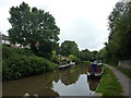
9
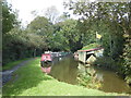
Moored narrowboats at Marple, Stockport
This is the Macclesfield Canal south-west of Church Lane Bridge, No 2.
Image: © Roger D Kidd
Taken: 5 Sep 2014
0.20 miles
10
Private wharf in Marple, Stockport
Houses here in Waterside have their own private mooring facilities on The Macclesfield Canal.
Image: © Roger Kidd
Taken: 7 Sep 2014
0.20 miles