IMAGES TAKEN NEAR TO
Barnsfold Road, STOCKPORT, SK6 7EL
Introduction
This page details the photographs taken nearby to Barnsfold Road, SK6 7EL by members of the Geograph project.
The Geograph project started in 2005 with the aim of publishing, organising and preserving representative images for every square kilometre of Great Britain, Ireland and the Isle of Man.

There are currently over 7.5m images from over14,400 individuals and you can help contribute to the project by visiting https://www.geograph.org.uk
Image Map
Images are licensed for reuse under creativecommons.org/licenses/by-sa/2.0
Notes
- Clicking on the map will re-center to the selected point.
- The higher the marker number, the further away the image location is from the centre of the postcode.
Image Listing (5 Images Found)
Images are licensed for reuse under creativecommons.org/licenses/by-sa/2.0
Image
Details
Distance
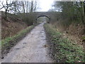
3
Road bridge over former railway
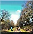
The road is Torkington Lane and the railway linked Marple and Macclesfield. The railway route now forms the basis of a shared use long distance path, Middlewood Way.
Image: © Kevin Waterhouse
Taken: 17 Aug 2024
0.20 miles
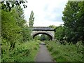
4
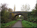
Torkington Lane bridge
A road bridge across the Middlewood Way, with a separate pipe bridge nearer the camera.
Image: © Stephen Craven
Taken: 5 Nov 2016
0.21 miles