IMAGES TAKEN NEAR TO
Station Road, STOCKPORT, SK6 6PA
Introduction
This page details the photographs taken nearby to Station Road, SK6 6PA by members of the Geograph project.
The Geograph project started in 2005 with the aim of publishing, organising and preserving representative images for every square kilometre of Great Britain, Ireland and the Isle of Man.

There are currently over 7.5m images from over14,400 individuals and you can help contribute to the project by visiting https://www.geograph.org.uk
Image Map
Images are licensed for reuse under creativecommons.org/licenses/by-sa/2.0
Notes
- Clicking on the map will re-center to the selected point.
- The higher the marker number, the further away the image location is from the centre of the postcode.
Image Listing (227 Images Found)
Images are licensed for reuse under creativecommons.org/licenses/by-sa/2.0
Image
Details
Distance
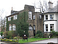
2
Houses on Station Road, Marple
Just west of the Peak Forest Canal.
Image: © Christine Johnstone
Taken: 10 May 2014
0.05 miles
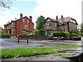
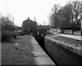
3
Lockside warehouse
Now occupied by offices.
Image: © Peter Turner
Taken: 16 Feb 2013
0.06 miles
4
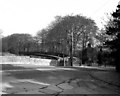
A626 road Bridge, Peak Forest Canal, Marple
The building, right centre, which looks as if it could have been a tollhouse, is in fact the lodge to Brabyns Hall, and is Grade 2 listed. The road is the A626, known here as Brabyns Brow. This is Bridge 17. I am indebted to Peter Royce for this information.
Image: © Dr Neil Clifton
Taken: 13 Apr 1981
0.06 miles
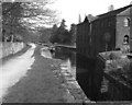
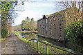
8
Marple Locks, Peak Forest Canal
The conservation of original canal buildings alongside can have an enhancing effect on the environment as is seen here with this small warehouse.
Image: © Dr Neil Clifton
Taken: 13 Apr 1981
0.07 miles
9
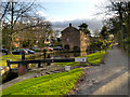
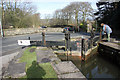
Lockside
The Peak Forest Canal at Lock number 9. One of a flight of 16 locks which raise the canal by 209 feet (64m) over the course of 1 mile. The large building behind carries the name "Lockside Mill"; it was built in the late eighteenth/early nineteenth century as a warehouse for Samuel Oldknow (http://en.wikipedia.org/wiki/Samuel_Oldknow )
Image: © David Dixon
Taken: 28 Nov 2012
0.07 miles
10
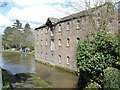
Converted canal warehouse
Canal warehouse converted into flats on St. Martin's Road (to rear) beside the Peak Forest Canal on the Marple flight of locks at Marple.
Image: © Mike Harris
Taken: 12 Apr 2008
0.07 miles