IMAGES TAKEN NEAR TO
Churchill Crescent, STOCKPORT, SK6 6HJ
Introduction
This page details the photographs taken nearby to Churchill Crescent, SK6 6HJ by members of the Geograph project.
The Geograph project started in 2005 with the aim of publishing, organising and preserving representative images for every square kilometre of Great Britain, Ireland and the Isle of Man.

There are currently over 7.5m images from over14,400 individuals and you can help contribute to the project by visiting https://www.geograph.org.uk
Image Map (Loading...)


Getting Data...Please wait
Leaflet Map data © OpenStreetMap
Images are licensed for reuse under creativecommons.org/licenses/by-sa/2.0
Notes
- Clicking on the map will re-center to the selected point.
- The higher the marker number, the further away the image location is from the centre of the postcode.
Image Listing (4 Images Found)
Images are licensed for reuse under creativecommons.org/licenses/by-sa/2.0
Image
Details
Distance
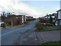
2

Marple Hall Drive
From the corner of Flagg Wood Avenue
Image: © Gerald England
Taken: 15 Dec 2009
0.17 miles
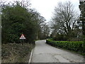
3

The Turnpike
At the corner of Prince's Drive.
Image: © Gerald England
Taken: 15 Dec 2009
0.21 miles
4
Pot Holes in Marple
A sign advises passing motorists and pedestrians of the imminent dangers. Perhaps filling in the potholes might have been a more pragmatic approach. Dale Road.
Image: © Peter Barr
Taken: 21 Mar 2012
0.25 miles