IMAGES TAKEN NEAR TO
Longhurst Lane, STOCKPORT, SK6 5PP
Introduction
This page details the photographs taken nearby to Longhurst Lane, SK6 5PP by members of the Geograph project.
The Geograph project started in 2005 with the aim of publishing, organising and preserving representative images for every square kilometre of Great Britain, Ireland and the Isle of Man.

There are currently over 7.5m images from over14,400 individuals and you can help contribute to the project by visiting https://www.geograph.org.uk
Image Map
Images are licensed for reuse under creativecommons.org/licenses/by-sa/2.0
Notes
- Clicking on the map will re-center to the selected point.
- The higher the marker number, the further away the image location is from the centre of the postcode.
Image Listing (7 Images Found)
Images are licensed for reuse under creativecommons.org/licenses/by-sa/2.0
Image
Details
Distance
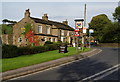
1
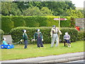
Be prepared
A bit early for Guy Fawkes in July; a scout and guide camp is nearby, in Mellor.
Image: © Peter Barr
Taken: 1 Aug 2011
0.06 miles
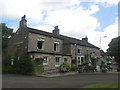
5
Sheep grazing near St Thomas's Church, Mellor
Image: © Bill Boaden
Taken: 30 Sep 2010
0.22 miles
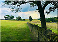
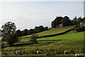
6

View from a stile near Mellor Hall
On a bridleway between the Vicarage and Mellor Hall, the view south.
Image: © Peter Barr
Taken: 1 Aug 2011
0.23 miles