IMAGES TAKEN NEAR TO
Cobden Edge, STOCKPORT, SK6 5NJ
Introduction
This page details the photographs taken nearby to Cobden Edge, SK6 5NJ by members of the Geograph project.
The Geograph project started in 2005 with the aim of publishing, organising and preserving representative images for every square kilometre of Great Britain, Ireland and the Isle of Man.

There are currently over 7.5m images from over14,400 individuals and you can help contribute to the project by visiting https://www.geograph.org.uk
Image Map
Images are licensed for reuse under creativecommons.org/licenses/by-sa/2.0
Notes
- Clicking on the map will re-center to the selected point.
- The higher the marker number, the further away the image location is from the centre of the postcode.
Image Listing (19 Images Found)
Images are licensed for reuse under creativecommons.org/licenses/by-sa/2.0
Image
Details
Distance
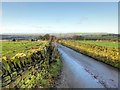
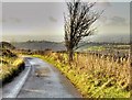
1
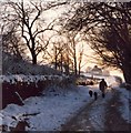
A winter's day on Cobden Edge, Mellor
The land rises ahead to just over 1000 feet, and is now crowned with a cross erected by Churches Together in Marple and District.
Image: © Geoff Heath
Taken: Unknown
0.05 miles
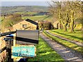
2
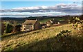
Cobden Farm
View of Cobden Farm from Cobden Edge.
Image: © Peter McDermott
Taken: 12 Nov 2017
0.06 miles
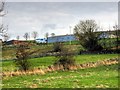
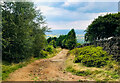
5
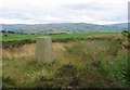
Mellor Moor
Out chasing trigs when I came across this tiny parcel of surviving moorland. Good berries and views too.
Image: © Richard Webb
Taken: 21 Jul 2004
0.13 miles