IMAGES TAKEN NEAR TO
Longhurst Lane, STOCKPORT, SK6 5AH
Introduction
This page details the photographs taken nearby to Longhurst Lane, SK6 5AH by members of the Geograph project.
The Geograph project started in 2005 with the aim of publishing, organising and preserving representative images for every square kilometre of Great Britain, Ireland and the Isle of Man.

There are currently over 7.5m images from over14,400 individuals and you can help contribute to the project by visiting https://www.geograph.org.uk
Image Map
Images are licensed for reuse under creativecommons.org/licenses/by-sa/2.0
Notes
- Clicking on the map will re-center to the selected point.
- The higher the marker number, the further away the image location is from the centre of the postcode.
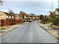
Image Listing (6 Images Found)
Images are licensed for reuse under creativecommons.org/licenses/by-sa/2.0
Image
Details
Distance
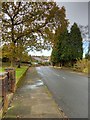
2
Clement Road, Marple Bridge
Leafy suburb and detached houses.
Image: © Peter Barr
Taken: 1 Aug 2011
0.15 miles
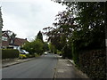
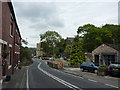
5
Low Lea Road, Marple Bridge
Looking away from Marple Bridge up Low Lea Road
Image: © Peter Fuller
Taken: 9 Feb 2010
0.23 miles
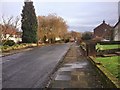
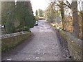
6
Longhurst Lane, Marple Bridge
Looking towards the town centre; and improvements to a pedestrian bridge over a stream, a tributary of the River Goyt.
Image: © Peter Barr
Taken: 1 Aug 2011
0.25 miles