IMAGES TAKEN NEAR TO
Central Drive, STOCKPORT, SK6 4PE
Introduction
This page details the photographs taken nearby to Central Drive, SK6 4PE by members of the Geograph project.
The Geograph project started in 2005 with the aim of publishing, organising and preserving representative images for every square kilometre of Great Britain, Ireland and the Isle of Man.

There are currently over 7.5m images from over14,400 individuals and you can help contribute to the project by visiting https://www.geograph.org.uk
Image Map
Images are licensed for reuse under creativecommons.org/licenses/by-sa/2.0
Notes
- Clicking on the map will re-center to the selected point.
- The higher the marker number, the further away the image location is from the centre of the postcode.
Image Listing (151 Images Found)
Images are licensed for reuse under creativecommons.org/licenses/by-sa/2.0
Image
Details
Distance
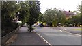


5
Sandy Lane, Romiley
Romiley Primary School on the right.
Image: © John Topping
Taken: 21 Feb 2013
0.07 miles
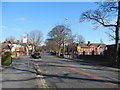
7

Romiley Forum
The Forum Theatre in the centre of Romiley.
Image: © Gerald England
Taken: 28 Jan 2010
0.09 miles
8

Elizabeth II postbox on Compstall Road, Romiley
Image: © JThomas
Taken: 21 Mar 2019
0.10 miles
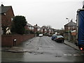
9
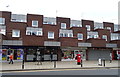
Shops on Compstall Road, Romiley
Showing position of Postbox No. SK6 412.
See Image] for postbox.
Image: © JThomas
Taken: 21 Mar 2019
0.10 miles
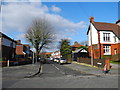
10
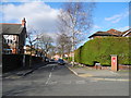
Park Road, Romiley
Viewed from Sandy Lane.
Image: © John Topping
Taken: 21 Feb 2013
0.10 miles