IMAGES TAKEN NEAR TO
Woodmount Close, STOCKPORT, SK6 4HN
Introduction
This page details the photographs taken nearby to Woodmount Close, SK6 4HN by members of the Geograph project.
The Geograph project started in 2005 with the aim of publishing, organising and preserving representative images for every square kilometre of Great Britain, Ireland and the Isle of Man.

There are currently over 7.5m images from over14,400 individuals and you can help contribute to the project by visiting https://www.geograph.org.uk
Image Map (Loading...)


Getting Data...Please wait
Leaflet Map data © OpenStreetMap
Images are licensed for reuse under creativecommons.org/licenses/by-sa/2.0
Notes
- Clicking on the map will re-center to the selected point.
- The higher the marker number, the further away the image location is from the centre of the postcode.
Image Listing (12 Images Found)
Images are licensed for reuse under creativecommons.org/licenses/by-sa/2.0
Image
Details
Distance
1
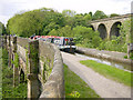
Marple Aqueduct, Peak Forest Canal
Marple Aqueduct, on the Peak Forest Canal, crosses the River Goyt just north of the flight of 16 locks at Marple.
Image: © Martin Clark
Taken: Unknown
0.07 miles
3
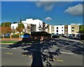
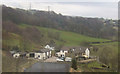
Cherry Tree House, Romiley
A modern, purpose-built residential home for the elderly. With the shadow of a tree.
Image: © Neil Theasby
Taken: 18 Oct 2022
0.18 miles
4
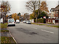
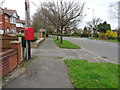
Houses on Compstall Road, Romiley
Showing position of Postbox No. SK6 324.
See Image] for postbox.
Image: © JThomas
Taken: 21 Mar 2019
0.22 miles
5
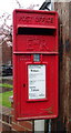
Elizabeth II postbox on Compstall Road, Romiley
Image: © JThomas
Taken: 21 Mar 2019
0.23 miles
6
Compstall Road, Romiley
Showing position of Postbox No. SK6 324.
See Image] for postbox.
Image: © JThomas
Taken: 21 Mar 2019
0.23 miles
7
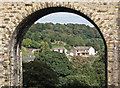
Upper Watermeetings Farm
The farm is viewed from Marple Aqueduct looking through one of the 12 arches of the Marple Viaduct.
Image: © Stephen Burton
Taken: 24 Sep 2013
0.23 miles
8
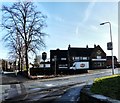
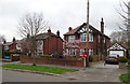
The Cherry Tree
At the junction of Compstall Road and Cherry Tree Lane, Romiley.
Update 2011 Image
Image: © Gerald England
Taken: 21 Jan 2009
0.23 miles
10
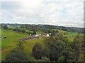
Upper Watermeetings Farm
View from a train between Romiley and Marple.
Image: © Gerald England
Taken: 7 Sep 2009
0.23 miles