IMAGES TAKEN NEAR TO
Lichfield Walk, STOCKPORT, SK6 3HE
Introduction
This page details the photographs taken nearby to Lichfield Walk, SK6 3HE by members of the Geograph project.
The Geograph project started in 2005 with the aim of publishing, organising and preserving representative images for every square kilometre of Great Britain, Ireland and the Isle of Man.

There are currently over 7.5m images from over14,400 individuals and you can help contribute to the project by visiting https://www.geograph.org.uk
Image Map (Loading...)


Getting Data...Please wait
Leaflet Map data © OpenStreetMap
Images are licensed for reuse under creativecommons.org/licenses/by-sa/2.0
Notes
- Clicking on the map will re-center to the selected point.
- The higher the marker number, the further away the image location is from the centre of the postcode.
Image Listing (7 Images Found)
Images are licensed for reuse under creativecommons.org/licenses/by-sa/2.0
Image
Details
Distance
1
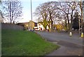
Hatherlow, Bredbury Green
The A627 (from Oldham to Hazel Grove) at its junction with Overdale Road, Bredbury Green is named simply "Hatherlow".
Image: © Gerald England
Taken: 19 Nov 2011
0.22 miles
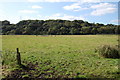
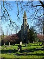
4
Hatherlow church at Bredbury Green
View from towpath of Peak Forest Canal
Image: © Raymond Knapman
Taken: 2 Nov 2011
0.24 miles
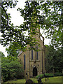
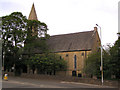
6
Hatherlow United Reformed Church
Photographed from Green Lane, Hatherlow.
Image: © Dave Dunford
Taken: 8 Apr 2017
0.24 miles
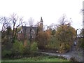
7
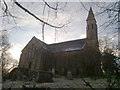
Hatherlow United Reformed Church
Seen from down below near the River Goyt. It was difficult to capture the whole church in one view.
Image: © Bill Boaden
Taken: 29 Nov 2010
0.25 miles