IMAGES TAKEN NEAR TO
Harrytown, STOCKPORT, SK6 3BX
Introduction
This page details the photographs taken nearby to Harrytown, SK6 3BX by members of the Geograph project.
The Geograph project started in 2005 with the aim of publishing, organising and preserving representative images for every square kilometre of Great Britain, Ireland and the Isle of Man.

There are currently over 7.5m images from over14,400 individuals and you can help contribute to the project by visiting https://www.geograph.org.uk
Image Map
Images are licensed for reuse under creativecommons.org/licenses/by-sa/2.0
Notes
- Clicking on the map will re-center to the selected point.
- The higher the marker number, the further away the image location is from the centre of the postcode.
Image Listing (10 Images Found)
Images are licensed for reuse under creativecommons.org/licenses/by-sa/2.0
Image
Details
Distance
1
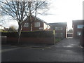
Harrytown Catholic High School
Now a specialist Science College.
Image: © Gerald England
Taken: 10 Nov 2012
0.11 miles
4
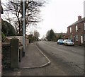
Bredbury Green
The junction of Clapgate and Harrytown.
Image: © Gerald England
Taken: 15 Jun 2010
0.16 miles
5
Harrytown
Viewed from the top deck of a bus.
Image: © Gerald England
Taken: 15 Jun 2010
0.18 miles
6
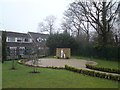
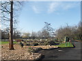
Peace Garden
At the St Christopher Centre, Harrytown Image
Image: © Gerald England
Taken: 22 Jan 2020
0.20 miles
7
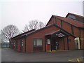
St Christopher Centre, Harrytown
Attached the church of Our Lady & St Christopher, Romily http://www.ourladyandstchristophersromiley.org.uk/st-christopher-centre/
Image: © Gerald England
Taken: 22 Jan 2020
0.22 miles
8
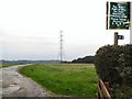
Diversion
The rough track on the left leads to Goyt Hall, across Clapgate farmland. However, the public right of way has been diverted by order of Stockport MBC (see inset), and now veers right towards Middle Farm before swinging left again and rejoining the Etherow+Goyt Valley way lower down, behind the stand of trees in the distance.
Image: © Roger May
Taken: 6 Oct 2005
0.23 miles
9
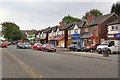
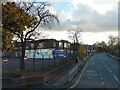
Berrycroft Lane (A6017)
Row of shops on Berrycroft Lane, looking towards Barrack Hill.
Image: © David Dixon
Taken: 10 Jun 2010
0.24 miles
10
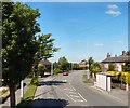
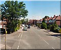
Higher Bents Lane
The A6017 approaching Harrytown.
Image: © Gerald England
Taken: 25 Feb 2010
0.25 miles