IMAGES TAKEN NEAR TO
St. Christophers Drive, STOCKPORT, SK6 3BD
Introduction
This page details the photographs taken nearby to St. Christophers Drive, SK6 3BD by members of the Geograph project.
The Geograph project started in 2005 with the aim of publishing, organising and preserving representative images for every square kilometre of Great Britain, Ireland and the Isle of Man.

There are currently over 7.5m images from over14,400 individuals and you can help contribute to the project by visiting https://www.geograph.org.uk
Image Map
Images are licensed for reuse under creativecommons.org/licenses/by-sa/2.0
Notes
- Clicking on the map will re-center to the selected point.
- The higher the marker number, the further away the image location is from the centre of the postcode.
Image Listing (78 Images Found)
Images are licensed for reuse under creativecommons.org/licenses/by-sa/2.0
Image
Details
Distance
1
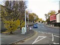
School Brow
The B6104 climbing out of Romiley at its junction with Gorsey Brow.
Image: © Gerald England
Taken: 19 Nov 2011
0.07 miles
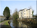
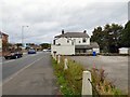
2
Gorsey Brow, Romiley
The junction of Gorsey Brow with School Brow (left), Stockport Road (B6104) and Padden Brook (near right).
Image: © John Topping
Taken: 4 Mar 2013
0.08 miles
3
Easy like Sunday Morning
View from the bottom of Gorsey Brow, up Stockport Road towards Romiley centre.
(a site user adds:The detached building in the centre of the picture was once the Craven Heifer public house)
Image: © Roger May
Taken: 28 Aug 2005
0.08 miles
4
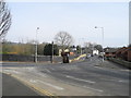
Barrack Hill
The A627 at the junction with the A6017. On the right is the car park of the former Cow & Calf Image
Image: © Gerald England
Taken: 14 Oct 2017
0.09 miles
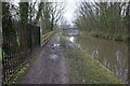
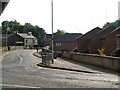
6
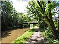
Bridge 13b
School Brow footbridge over the Peak Forest Canal.
Image: © Gerald England
Taken: 8 Jul 2017
0.10 miles
7
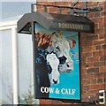
Sign of the Cow & Calf
Sign for the Cow & Calf Image
Image: © Gerald England
Taken: 21 May 2015
0.10 miles
8
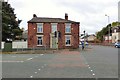
Former Cow & Calf
The former Robinsons pub Image is now closed. Originally it was The Hare & Hounds, became The Commercial Inn and later The Cow & Calf. Locally it was known as "Top House" where sparrow shooting contests were once held.
Image: © Gerald England
Taken: 14 Oct 2017
0.10 miles