IMAGES TAKEN NEAR TO
Hawthorne Grove, STOCKPORT, SK6 2PJ
Introduction
This page details the photographs taken nearby to Hawthorne Grove, SK6 2PJ by members of the Geograph project.
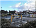
The Geograph project started in 2005 with the aim of publishing, organising and preserving representative images for every square kilometre of Great Britain, Ireland and the Isle of Man.

There are currently over 7.5m images from over14,400 individuals and you can help contribute to the project by visiting https://www.geograph.org.uk
Image Map
Images are licensed for reuse under creativecommons.org/licenses/by-sa/2.0
Notes
- Clicking on the map will re-center to the selected point.
- The higher the marker number, the further away the image location is from the centre of the postcode.
Image Listing (135 Images Found)
Images are licensed for reuse under creativecommons.org/licenses/by-sa/2.0
Image
Details
Distance
1
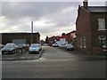
Lime Street
Leading to the Crosland Industrial Estate.
Image: © Gerald England
Taken: 13 Dec 2010
0.04 miles
2
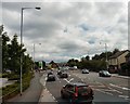
Stockport Road West
The A560 towards Hyde.
Image: © Gerald England
Taken: 13 Dec 2010
0.04 miles
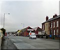
3
Stockport Road West
The A560 towards Hyde. The bus stop is labelled "Minibuses only". Why even a minibus would want to stop here on this busy road I can't imagine. It is just past the exit from Morrisons and Homebase and there is a layby for regular buses lower down the road.
Image: © Gerald England
Taken: 12 Nov 2011
0.04 miles
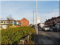
4
Roadworks in Bredbury
The road is being resurfaced. Although the work is taking place overnight it is still causing massive traffic jams during the day.
Image: © Gerald England
Taken: 7 Feb 2017
0.05 miles
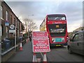
5
Stockport Road West
Viewed from the top deck of a bus outside Morrisons.
Image: © Gerald England
Taken: 19 Jul 2010
0.06 miles
6
Stockport Road West
The A560 at Bredbury. What looks like fog in the distance is actually fog from the fire at a waste-recycling works that caught fire three days earlier and though contained is still burning.
Image: © Gerald England
Taken: 24 Aug 2013
0.08 miles
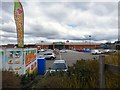
7
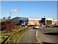
Homebase, Bredbury
The Homebase store at Bredbury. In the background is what is left of a once large industrial area.
Image: © Gerald England
Taken: 8 Mar 2010
0.09 miles
8
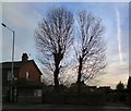
Pollarded Trees at Bredbury
Behind the bus-stop on Stockport Road West are two pollarded trees.
Image: © Gerald England
Taken: 14 Jan 2014
0.09 miles
9
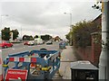
Exit from Morrisons
The exit from Morrisons at Bredbury. A sliver of dirty snow remains from the snowfall two days before. The carpark on the opposite side serves Homebase.
Image: © Gerald England
Taken: 6 Feb 2012
0.10 miles
10
Homebase, Bredbury
The Homebase store in Bredbury was built on the site of the former nightclub Quaffers. Now the store incorporates an Argos outlet. In the carpark is a clothes4cash collection point.
Image: © Gerald England
Taken: 16 Apr 2016
0.10 miles