IMAGES TAKEN NEAR TO
Kay Avenue, STOCKPORT, SK6 2HL
Introduction
This page details the photographs taken nearby to Kay Avenue, SK6 2HL by members of the Geograph project.
The Geograph project started in 2005 with the aim of publishing, organising and preserving representative images for every square kilometre of Great Britain, Ireland and the Isle of Man.

There are currently over 7.5m images from over14,400 individuals and you can help contribute to the project by visiting https://www.geograph.org.uk
Image Map
Images are licensed for reuse under creativecommons.org/licenses/by-sa/2.0
Notes
- Clicking on the map will re-center to the selected point.
- The higher the marker number, the further away the image location is from the centre of the postcode.
Image Listing (55 Images Found)
Images are licensed for reuse under creativecommons.org/licenses/by-sa/2.0
Image
Details
Distance
1
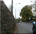
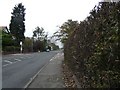
Lower Bredbury
Stockport Road West in Lower Bredbury used to be the A560 but has now been reclassified as the B6104.
Image: © Gerald England
Taken: 5 Nov 2008
0.04 miles
2
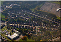
Lower Bredbury from the air
Arden Primary School is prominent http://www.arden.stockport.sch.uk/ .
Image: © Thomas Nugent
Taken: 19 Oct 2018
0.10 miles
3
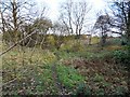
Wooded Land at Lower Bredbury
If the now-abandoned plans for an A6(M) motorway as an extension of the M60 motorway towards Hazel Grove had gone ahead, this land would now lie under a motorway bridge.
Image: © Gerald England
Taken: 11 Nov 2009
0.11 miles
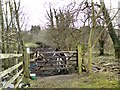
4
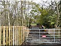
Grazing at Bredbury
Access to grazing land at Bredbury.
Image: © Gerald England
Taken: 31 Oct 2017
0.12 miles
5
Lower Bredbury
Looking up Stockport Road West towards the junction with the A560.
Image: © Gerald England
Taken: 5 Nov 2008
0.12 miles
6
Grazing at Bredbury
A happy looking horse with a nice bale of hay. I didn't get too close to read it properly but the notice on the gate appeared to be seeking information about a lost ferrett.
Image: © Gerald England
Taken: 20 Feb 2012
0.13 miles
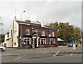
7
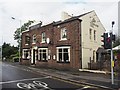
The Travellers Call
Pub on Stockport Road, close to the railway station
Image: © Graham Hogg
Taken: 3 Sep 2020
0.15 miles
8
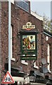
The Travellers' Call: Signage
Above the hanging sign for the pub Image is a mosaic of the name on the wall. Attached to a lamppost is a cycle lane sign.
Image: © Gerald England
Taken: 31 Oct 2017
0.15 miles
9
Travellers' Call
A J W Lees' pub. The - S' - seems have dropped off the gable wall which has been repainted since 2012 Image
Image
Image: © Gerald England
Taken: 31 Oct 2017
0.15 miles
10
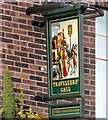
Sign for the Travellers' Call
The sign of the Travellers' Call Image
Image: © Gerald England
Taken: 11 Nov 2009
0.15 miles