IMAGES TAKEN NEAR TO
Lyndhurst Avenue, STOCKPORT, SK6 2AJ

Introduction

This page details the photographs taken nearby to Lyndhurst Avenue, SK6 2AJ by members of the Geograph project.

The Geograph project started in 2005 with the aim of publishing, organising and preserving representative images for every square kilometre of Great Britain, Ireland and the Isle of Man.

There are currently over 7.5m images from over14,400 individuals and you can help contribute to the project by visiting https://www.geograph.org.uk

Image Map


Images are licensed for reuse under creativecommons.org/licenses/by-sa/2.0
Notes
  • Clicking on the map will re-center to the selected point.
  • The higher the marker number, the further away the image location is from the centre of the postcode.

Image Listing (148 Images Found)

Images are licensed for reuse under creativecommons.org/licenses/by-sa/2.0
  • ...
Image
Details
Distance
1
Lyndhurst Avenue
A cul-de-sac of terraced houses off Stockport Road East. Viewed from the footpath that connects it to Elm Street.
Image: © Gerald England Taken: 6 Feb 2012
0.01 miles
2
Footpath to Elm Street
Footpath providing a short cut between Stockport Road East near Bredbury railway station to Elm Road. The area is now part of a community orchard Image
Image: © Gerald England Taken: 12 Nov 2011
0.04 miles
3
Footpath from Elm Street
Leading to Stockport Road East.
Image: © Gerald England Taken: 6 Feb 2012
0.04 miles
4
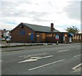
Rat Pit
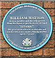
Bents Lane Social Club was named after the former wooden building built on stilts, which it replaced. It had been known locally as "The Rat Pit", and now boasts that name on its frontage. The building is the local polling station for elections. Can the locals be the only ones in the United Kingdom to vote at an officially designated rat pit? . A plaque Image on the wall unveiled in 2007 commemorates William Watson who was born in house that previously stood on the site.
Image: © Gerald England Taken: 18 Aug 2010
0.04 miles
5
William Watson
Blue plaque erected by Stockport Heritage Trust in 2007 http://stockporttrust.blogspot.com/2007/09/plaque-unveiling-at-rat-pit-was-great.html at the Rat Pit Image on Lower Bents Lane. William Watson who grew up in a house on this site was a stoker on the Titanic and the only person from Stockport to perish on the ship.
Image: © Gerald England Taken: 18 Aug 2010
0.04 miles
6
The end of the Rat Pit
Bents Lane Social Club was named after the former wooden building built on stilts, which it replaced. It had been known locally as "The Rat Pit". A plaque on the wall unveiled in 2007 Image commemorates William Watson who was born in a house that previously stood on the site. He was a stoker on the ill-fated Titanic and was buried at sea on the 24th April 1912, aged 27 years. It is now closed and the building for sale.
Image: © Gerald England Taken: 20 Oct 2018
0.05 miles
7
Egerton Park Community Orchard
Signboard by the Stockport Road East entrance to what is now known as Egerton Park Community Orchard. Previously this was waste ground to the SW of the New Mills to Manchester railway line stretching either side of Redhouse Lane. It is one of 12 new community woodlands in Stockport Metropolitan Borough.
Image: © Gerald England Taken: 12 Nov 2011
0.05 miles
8
Baytree Drive, Bredbury
Image: © M J Richardson Taken: 12 Dec 2007
0.05 miles
9
Stockport Road East
The A560 towards Hyde from the junction with Lower Bents Lane.
Image: © Gerald England Taken: 15 Oct 2008
0.05 miles
10
Stockport Road East
Viewed from the top deck of a bus at Auburn Avenue. Ahead is Bredbury Station. In the foreground are the offices of a driving school.
Image: © Gerald England Taken: 19 Jul 2010
0.05 miles
  • ...