IMAGES TAKEN NEAR TO
Rodney Drive, STOCKPORT, SK6 1RU

Introduction

This page details the photographs taken nearby to Rodney Drive, SK6 1RU by members of the Geograph project.

The Geograph project started in 2005 with the aim of publishing, organising and preserving representative images for every square kilometre of Great Britain, Ireland and the Isle of Man.

There are currently over 7.5m images from over14,400 individuals and you can help contribute to the project by visiting https://www.geograph.org.uk

Image Map


Images are licensed for reuse under creativecommons.org/licenses/by-sa/2.0
Notes
  • Clicking on the map will re-center to the selected point.
  • The higher the marker number, the further away the image location is from the centre of the postcode.

Image Listing (192 Images Found)

Images are licensed for reuse under creativecommons.org/licenses/by-sa/2.0
  • ...
Image
Details
Distance
1
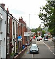
Stockport Road East
Viewed from the top deck of a bus by St Mark's church.
Image: © Gerald England Taken: 19 Jul 2010
0.05 miles
2
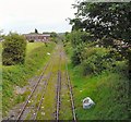
From Mill Lane Bridge
The railway line was once part of a busy route from Woodley through Stockport (Tiviot Dale) to points West. Now it leads only to an industrial site at Bredbury. Viewed from the Mill Lane bridge looking towards Bredbury. On the right is the edge of Woodley Playing Fields.
Image: © Gerald England Taken: 19 Feb 2010
0.05 miles
3
Stockport Road East
The A560 viewed from the top deck of a bus outside St Mark's church.
Image: © Gerald England Taken: 24 Dec 2011
0.06 miles
4
Footbridge at Woodley
The bridge over the railway line on the footpath from Woodley to Bredbury Park.
Image: © Gerald England Taken: 22 Apr 2009
0.06 miles
5
Railway towards Woodley
The line used to travel to Stockport (Tiviot Dale) and beyond but now only serves an industrial site in Bredbury.
Image: © Gerald England Taken: 22 Apr 2009
0.06 miles
6
Vandalised Bus Shelter
Bus shelter on Stockport Road West. Apparently this was one of several that had been vandalised the previous evening. The shattered remains of the glass still littered the pavement.
Image: © Gerald England Taken: 21 Jan 2017
0.06 miles
7
Public footpath #52
Heading North off Stockport Road East at Woodley.
Image: © Gerald England Taken: 25 May 2011
0.06 miles
8
Rodney Drive, Bredbury
Image: © John Topping Taken: 4 Mar 2013
0.07 miles
9
Lines to Woodley
Grass grows down the middle of the railway lines towards Woodley. Formerly part of the line which ran from Woodley through Stockport Tiviot Dale and on towards Liverpool. Now it terminates at a waste recycling plant in Bredbury.
Image: © Gerald England Taken: 25 May 2011
0.07 miles
10
Bredbury St Mark's
St Marks is the Church of England church for Woodley and parts of Bredbury in Stockport.
Image: © David Dixon Taken: 22 Oct 2011
0.07 miles
  • ...