IMAGES TAKEN NEAR TO
Northumberland Road, STOCKPORT, SK5 8NY
Introduction
This page details the photographs taken nearby to Northumberland Road, SK5 8NY by members of the Geograph project.
The Geograph project started in 2005 with the aim of publishing, organising and preserving representative images for every square kilometre of Great Britain, Ireland and the Isle of Man.

There are currently over 7.5m images from over14,400 individuals and you can help contribute to the project by visiting https://www.geograph.org.uk
Image Map
Images are licensed for reuse under creativecommons.org/licenses/by-sa/2.0
Notes
- Clicking on the map will re-center to the selected point.
- The higher the marker number, the further away the image location is from the centre of the postcode.
Image Listing (28 Images Found)
Images are licensed for reuse under creativecommons.org/licenses/by-sa/2.0
Image
Details
Distance
1

Hollow End Towers, Brinnington
Image: © John Topping
Taken: 2 May 2013
0.00 miles
2
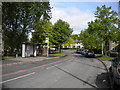
North end of Northumberland Road, Brinnington
Image: © Richard Vince
Taken: 12 May 2018
0.04 miles
3
Hollow End, Brinnington
On the left is a small car park for Reddish Vale Country Park,
Image: © John Topping
Taken: 2 May 2013
0.05 miles
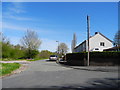
4
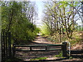
Entrance to Reddish Vale Country Park
At the end of Northumberland Road/Hollow End, Brinnington.
Image: © John Topping
Taken: 2 May 2013
0.06 miles
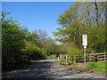
5
Reddish Vale Country Park
The Trans Pennine Trail near Hollow End.
Image: © David Dixon
Taken: 7 Oct 2012
0.07 miles
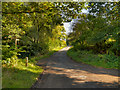
6

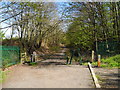
Approaching railway bridge, Blackberry Lane, Brinnington
This narrow bridge, which presumably predates the housing development either side of it, carries Blackberry Lane across the direct railway line from New Mills to Manchester, a little way north west of Brinnington station.
Image: © Richard Vince
Taken: 12 May 2018
0.07 miles
7

Romiley to Ashburys railway line
North-west of Brinnington station, with Ashburys signal box 3 aspect automatic signal No 941 in view, for the down line.
Image: © John Topping
Taken: 2 May 2013
0.08 miles
8
Trans Pennine Trail, Hollow End/Brinnington (2)
Heading south to Tiviot Dale Weir and Stockport Town Centre.
Image: © John Topping
Taken: 2 May 2013
0.08 miles
9
Trans Pennine Trail, Hollow End/Brinnington (1)
Heading north towards Reddish Vale Country Park Visitor Centre.
Image: © John Topping
Taken: 2 May 2013
0.08 miles
10
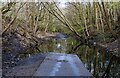
Trans Pennine Trail
Flooded part of the Trans Pennine Trail.
Image: © Peter McDermott
Taken: 11 Apr 2021
0.08 miles