IMAGES TAKEN NEAR TO
Lancashire Hill, STOCKPORT, SK5 7SD
Introduction
This page details the photographs taken nearby to Lancashire Hill, SK5 7SD by members of the Geograph project.
The Geograph project started in 2005 with the aim of publishing, organising and preserving representative images for every square kilometre of Great Britain, Ireland and the Isle of Man.

There are currently over 7.5m images from over14,400 individuals and you can help contribute to the project by visiting https://www.geograph.org.uk
Image Map
Images are licensed for reuse under creativecommons.org/licenses/by-sa/2.0
Notes
- Clicking on the map will re-center to the selected point.
- The higher the marker number, the further away the image location is from the centre of the postcode.
Image Listing (132 Images Found)
Images are licensed for reuse under creativecommons.org/licenses/by-sa/2.0
Image
Details
Distance
1
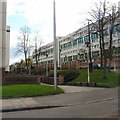
The Bentleys
Apartment block on Lancashire Hill from Kings Court.
Image: © Gerald England
Taken: 26 Mar 2014
0.02 miles
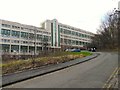
2
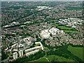
Lancashire Hill from the air
The towerblocks and adjacent low-rise blocks near Penny Lane are very reminiscent of Eastern European cities, but on a much smaller scale.
Image: © Thomas Nugent
Taken: 13 Jun 2014
0.02 miles
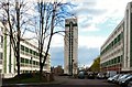
3
The Bentleys
Five-storey apartment block off Lancashire Hill. Behind The Bentleys are the high-rise tower blocks Pendlebury Towers and Hanover Towers.
Image: © Gerald England
Taken: 21 Jan 2014
0.04 miles
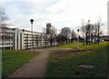
4
High-rise living on Lancashire Hill
These high-rise apartments are on the side of Lancashire Hill. On the left is Stonemill Terrace. On the right is The Bentleys. The tower block in the middle is Pendlebury House. Behind it but blocked from view is another tower-block Hanover House.
Image: © Gerald England
Taken: 26 Mar 2014
0.04 miles
6
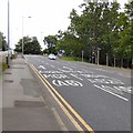
Lancashire Hill
The B6167 out of Stockport towards Reddish. At the top of the hill is a large roundabout with the . A626. The left hand lane is for Heaton Chapel and the A6 to Manchester. The right hand lane is for Tiviot Way down to the M60 at Portwood.
New mapping now shows the A626 through Heaton Chapel and Portwood as the A6188 but as yet there is no new signage indicating the change of number.
Image: © Gerald England
Taken: 15 Jun 2019
0.05 miles
7
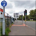
Lancashire Hill
Above the Pelican crossing on Lancashire Hill the road divides intotwo lanes going uphill. The left hand lane is for the A626 to Heaton Chapel and the A6 to Manchester. The right hand lane is for the B6167 to Reddish and the A626 Tiviot Way for Marple going down to the M60 at Portwood.
New mapping now shows the A626 through Heaton Chapel and Portwood as the A6188 but as yet there is no new signage indicating the change of number.
Image: © Gerald England
Taken: 15 Jun 2019
0.06 miles
8
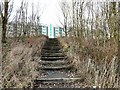
Steps to Stonemill Terrace
From Penny Lane Fields.
Image: © Gerald England
Taken: 21 Jan 2014
0.06 miles
9
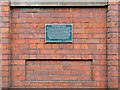
The Stockport Canal
The plaque marks the line of the canal which
terminated behind Nelstrop's flour mill. It
opened in 1797 as a branch of the Ashton Canal
to serve the developing town of Stockport.
Known as Lanky Cut, it carried goods
and passengers to and from the many mills
along the 4.2 miles from the junction at
Clayton to its terminus at Stockport.
Sponsored by Manchester and Stockport Canal Society
Manchester Airport Community Trust Fund www.mscs.org.uk
Image: © Gerald England
Taken: 15 Jun 2019
0.09 miles
10
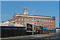
Albion Mill, Heaton Norris
This is actually a working flour mill, operated by Nelstrops. The main building is the second one on the site and dates from 1893. Many extensions since including various silos (Image]).
According to Wikipedia, "the mill uses wheat from East Anglia, and imports Manitoba wheat from Canada and Spring wheat from the US, which is brought by ship to Seaforth Dock in Liverpool and then brought to Stockport in 20 tonne bulk wheat lorries, typically 1,600 tonnes a week. The flour produced at the mill is typically sold to local bakers and supermarkets in England, as well as being exported to Nigeria, Egypt and Jordan."
Image: © Stephen Richards
Taken: 18 Aug 2016
0.09 miles